Leen Helmink Antique Maps
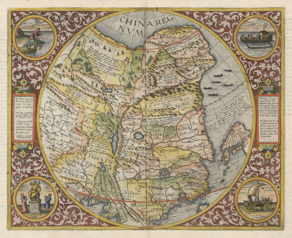
Antique map of China by de Jode
Stock number: 18652
Zoom ImageCartographer(s)
Cornelis de Jode (biography)
Title
China Regnum
First Published
Antwerp, 1593
This Edition
1593 first and only edition
Size
36.5 x 45.0 cms
Technique
Condition
excellent
Price
$ 27,500.00
(Convert price to other currencies)
Description
One of the rarest, most sought-after, and most decorative early maps of China. Published by Cornelius de Jode of Antwerp, 1593.
Hand-coloured double-page engraved hemispherical map, the corners decorated with vignettes, two pages of Latin text describing China on verso.
A pristine example of an important and distinctive map, seminal to any China collection. One of the earliest maps of China printed in Europe, and one of the rarest and most sought after of all early Western maps of China. While all of De Jode's maps are rare, this one is even more so, as it appeared in only one single 1593 edition of the De Jode atlas Speculum Orbis Terrae (Mirror of the World).
The European mapping of China began to take first, if inexact, shape in the 16th century, due primarily to the voyages of Portuguese traders and Jesuit missionaries, supplemented with the medieval accounts of Marco Polo of Venice and the Greek geography texts from classical antiquity.
Only the second map of China printed in Europe. The map is based on the work of the Portuguese Jorge de Barbuda, whose map of China first appeared in the work of Cornelius de Jode's competitor Abraham Ortelius in 1584. While well regarded by scholars today, De Jode's atlas was commercially no match for Ortelius's. This edition was to be the last: after the death of Cornelis in 1600 the plates were bought by Joan Baptista Vrientius, then the owner of the Ortelius plates, merely to suppress them.
Although this map is derived from the Jorge de Barbuda model, it has been significantly updated with the latest European discoveries. The map has been recast in a north-south orientation, and the view shifted north to show north-eastern Tartary and inner Asia. The new information is mainly derived from Jesuit sources like Giovanni Pietro de Maffei, although de Jode also acknowledges the author Juan González de Mendoza as source for the map.
China is set within a circle, surrounded by elaborate strap-work borders with floral decorations. In each of the four corner roundels is an illustration of exotic, curious or novel subject taken from the accounts of early travelers. These nicely engraved vignettes on De Jode's map pre-date the illustrations found in other works and derive from contemporary Jesuit reports. The scenes are depicted in two elegant strap-work cartouches and provide some of the earliest Western illustrations of any aspect of Chinese life.
- a man using a cormorant to catch fish
- a triple-headed deity being worshipped/venerated by two figures
- a Chinese family fishing boat with a a chimney-topped cabin and a domestic duck pen
- a wind wagon, the famous wind-powered chariots or land yachts, which commonly appear on late-16th-century European maps and prints.
This map of China also covers Northeast Asia and parts of western Japan including Kyushu, Shikoku, and most of mainland Honshu. The emergent shape of the Korean peninsula (Costa de Cooira) and Gulf of Pecheli (Bohai) are firsts on a European map.
Note the over-sized and detailed representation of the Pearl River Estuary, reflecting its importance in European trade. Cantaon (Guangzhou), Macao (Macau) and other places are identified.
The Great Wall is prominently depicted across northern China. Even though Cornelius de Jode drew on the same sources as Abraham Ortelius, De Jode presents the China coastline more accurately, probably based on a Portuguese manuscript chart of 1573 by Fernao Vaz Dourado.
The map also includes an early treatment of the Himalayas, including a relatively detailed depiction of the complicated and still poorly understood Ganges River and its tributaries. In the north are fascinating thematic scenes of the nomadic tribes of Tartaria, along with an open and inviting polar ocean to the north, showing the Northeast Sea Passage from Europe to China, which would in the next several years be explored by Dutch expeditions under command of captain Willem Barentsz.
De Jode’s map of China has long been sought by collectors and institutions as one of the most rare and visually arresting maps ever produced of China in the West.
Gerard de Jode (c.1509-1591)
Cornelis de Jode (son) (1568-1600)
Gerard de Jode originally issued his atlas in 1578 to compete with Ortelius' atlas with little success. In 1593, two years after his death, Gerard's son Cornelius re-issued the atlas. The success of the atlas was very limited due to heavy competition with Ortelius, who also seems to have bought many copies of de Jode's atlas to take them off the market. Because of this, both editions of the de Jode atlas are exceptionally rare.
"Gerard de Jode, born in Nijmegen, was a cartographer, engraver, printer and publisher in Antwerp, issueing maps from 1555 more or less in the same period as Ortelius. He was never able to offer very serious competition to his more businesslike rival although, ironically, he published Ortelius's famous 8-sheet World Map in 1564. His major atlas, now extremely rare, could not be published until 1578, eight years after the 'Theatrum', Ortelius having obtained a monopoly for that period.
The enlarged re-issue by his son in 1593 is more frequently found. On the death of Cornelis, the copper plates passed to J.B. Vrients (who bought the Ortelius plates about the same time) and apparently no further issue of the atlas was published."
(Moreland & Bannister).
"After the death of Cornelis in 1600, the copper-plates came into the hands of Jan Baptiste Vrients, then the publisher of Ortelius' Theatrum. Apparantly Vrients must have bought them to prevent any further publication of the Speculum."
(Koeman)
Related Categories
Related Items
