Leen Helmink Antique Maps
The missing chart of the route
The item below has been sold, but if you enter your email address we will notify you in case we have another example that is not yet listed or as soon as we receive another example.
Stock number: 19018
Zoom ImageCartographer(s)
Houtman
Title
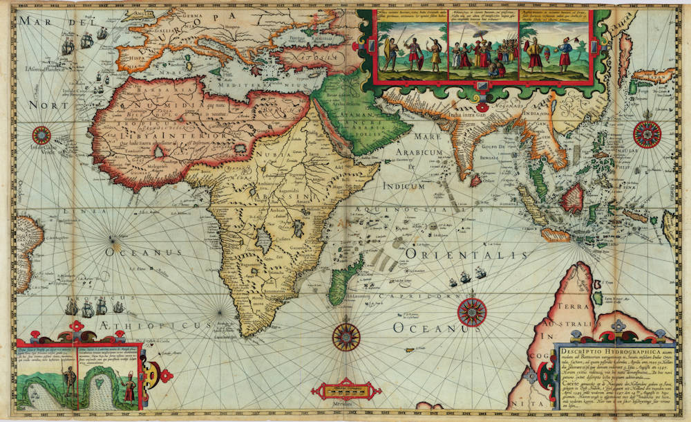
DESCRIPTIO HYDROGRAPHICA accommodata ad Battavorum navigationem in Javam insulam Indiæ Orientalis, factam; ad quam postridie Calendas Aprilis ann. 1595 ex Hollandia solverunt et ex qua domum redierunt 3. Idus Augusti an. 1597. Horum exitus reditusq3 via his notis ooo demonstratur. De hac navigatione extat descriptio lectu perquam admiranda
First Published
Amsterdam, 1598
This Edition
1598
Technique
Condition
excellent
Price
This Item is Sold
Description
Enter the Dutch
The dreams and labours of Petrus Plancius and Jan Huyghen van Linschoten culminated in the Dutch First Fleet to the Indies taking place from 1595 to 1597. It was instrumental in the opening up of the Indonesian spice trade to the merchants that would soon form the United Dutch East India Company (VOC). This famous pioneering voyage, commanded by Cornelis de Houtman, would abruptly end the Portuguese Empire ́s trade monopoly for the East and it would dramatically change the Indian Ocean theatre, notably the balance of power and the rules of trade. Right from this first voyage onward, the Dutch were going to dominate the East Indies and its trade for more than 350 years.
Condition
Rarity
Only copies known (all uncoloured):
* Amsterdam, Maritime Museum
* Rotterdam, Maritime Museum
* Verhoeff VOC Collection (The Netherlands)
Monumenta Cartographica Neerlandica, Vol VII, 2003
In 1915, Burger prepared a description of all maps known to him that Cornelis Claesz had published separately between 1591 and 1598. Burger suspected that Claesz had also published a large map pertaining to the first Dutch expedition to the Orient. He based his assumption on two facts. One piece of evidence was the small but highly instructive general map that appeared on the title page of Lodewijcksz's printed journal. Furthermore, Burger's suspicion was based on the fact that also Théodor de Bry, in the third volume of his Petits Voyages, included a map showing the entire route travelled by Cornelis de Houtman on that voyage. Thus, De Bry must have copied his map from an original one that had been published previously in Amsterdam. Burger's suspicion has been confirmed; three copies have been traced in the past 40 years.
A scrollwork cartouche in the lower right corner contains the title of the map in Latin and Dutch. A scale bar in German miles is drawn in a simple cartouche running along the middle of the map's lower edge. As decorative elements, the map image includes various figures from the journal of Willem Lodewijcksz. A little map of Mossel Bay in Southern Africa and one of the Bay d’Antongil on Madagascar, are placed in the lower left corner. Both are accompanied by a text in Latin. A panel with three figures representing the inhabitants of Bantam and its surroundings is shown in the upper right corner. The series begins with a presentation of the soldiers, followed in the central piece by a depiction of their commander. Farmers are shown in the picture on the right side.
On both sides, a latitude scale is shown (55°N-54°S); midway of the map borders, the celestial directions are marked in Latin. Emanating from a central compass rose, compass lines are drawn to eight 16-pointed compass roses, four of which are completely filled in. The name of the engraver is not given, but in view of the strong similarity to the signed general map of the Second Voyage, the map is in all likelihood the work of Benjamin Wright.
The map shows the area between the easternmost point of Brazil in the west and the western point of New Guinea in the east. In the north, the map image reaches from Emden in Europe and Korea in Asia to the protuberance of a large TERRA AUSTRALIS INCOGNITA in the south. Contemporary material was used as source for the representations; this consisted mainly of maps that had recently been published by Cornelis Claesz. For instance, the coasts, islands, and shallows in the Indian Ocean were copied from the maps in Van Linschoten’s Itinerario (1596), while most of the Indonesian archipelago and the Philippines corresponds in terms of drawing and toponyms to Plancius's map of the Moluccan Spice Islands (1592). For the depiction of Korea and Japan, which were no longer included on Plancius's map, the model was Luis Teixeira's map of this area found in Ortelius's Theatrum Orbis Terrarum (1595). Plancius's hypothetical coastline of South Java has been left out. It is striking that not a single Dutch name appears anywhere on the map. Nor are there any names that are derived directly from De Houtman's voyage.
The main purpose of this general map was to depict the route of the first Dutch fleet to sail to the East Indies in 1595-97; a voyage which had received so much acclaim for its success. The entire route taken by Cornelis de Houtman is drawn on the map. Along the route heading toward the Orient (Exitus), four ships are depicted twice; on the homeward journey (Reditus), the three ships that remained are also depicted twice. The route they sailed is described extensively in the previous section of this chapter. This map was listed for sale in Cornelis Claesz's Const ende Caert-Register (1609) in the section under the heading ‘De Caerten van alle Navigatien'. There, together with the 50 plates taken from the journal, it is offered for the price of "26 stuivers" [pennies].
(Günter Schilder)
Related Categories
Antique maps of the World
Antique maps of the East India Company
Antique maps of Australia
Antique maps of Japan
Antique maps of China
Antique maps of the Philippines
Antique maps of Southeast Asia
Antique maps of India and Ceylon
Antique maps of Korea
Antique maps of the Middle East
Antique maps of Asia
Antique maps of Africa
Related Items
