Leen Helmink Antique Maps & Atlases
www.helmink.com
Blaeu - GVIANA sive Amazonum Regio
Certificate of Authentication
This is to certify that the item illustrated and described below is a genuine and
original antique map or print that was published on or near the given date.
Dr Leendert Helmink, Ph.D.
Cartographer
Willem Janszoon Blaeu
First Published
Amsterdam, 1630
This edition
1662 plano binding
Size
37.1 x 49.2 cms
Technique
Copper engraving
Stock number
19167
Condition
mint
Description
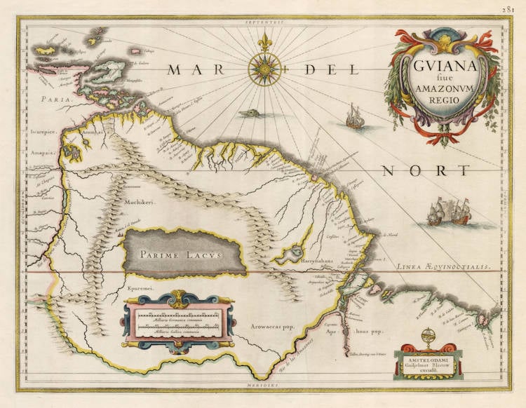
GVIANA sive AMAZONVM REGIO
GUYANA or the Region of the Amazons
One of the earliest and most decorative maps of the Guyanas, as well as one of the most appealing of all Blaeu maps.
The map is printed from one of the handsome copperplates that Willem Blaeu had acquired in 1629 from the estate of Jodocus Hondius the Younger, and that enabled Blaeu to finally publish his own atlas of the world.
At first sight, Jodocus Hondius the Younger appears to have loosely based this map on his father's (Jodocus Hondius the Elder) 1598 map of El Dorado, but closer inspection shows that junior must have used updated different sources and toponyms, and he also restricts himself to the eastern part of that map.
The Amazon river and basin was named after the Amazon tribe in Greek Mythology, a tribe of female warriors and hunters, who surpassed men in physical agility and strength, in archery, riding skills, and the arts of combat. Their society was closed for men and they only raised their daughters and returned their sons to their fathers, with whom they would only socialize once a year in order to reproduce.
In classical antiquity, late antiquity, Middle Ages and Renaissance literature there was a lot of speculation and different theories about the Amazon homeland. They had to be somewhere.
Amazons continued to be subject of scholarly debate during the European Renaissance, and with the onset of the Age of Exploration, encounters were reported from ever more distant lands. In 1542, Francisco de Orellana managed to sail the length of the Amazon River, in one of the most improbably successful voyages in history, naming it after the Icamiabas a tribe of warlike women he had fought on the Nhamundá River, a tributary of the Amazon. Afterwards the whole basin and region of the Amazon (Amazônia in Portuguese, Amazonía in Spanish) were named after the river. Amazons also figure in the accounts of both Christopher Columbus and Walter Raleigh.
The name 'Amazon' arose from a battle Francisco de Orellana fought with a tribe of Tapuyas. Orellana described the river as "the river of the Amazons", referring to the mythical Amazons of the ancient writers. A skirmish with these South American warrior women reportedly took place on 24 June 1542 while Orellana was approaching the Trombetus River, in the neighborhood of the Ilha Tupinambarama at the junction with the River Madeira.
It has been suggested that what Orellana actually engaged was an especially warlike tribe of Native Americans whose warrior men wore long hair and thus appeared to him to be women. See Theobaldo Miranda Santos, Lendas e mitos do Brasil ("Brazil's legends and myths", Companhia Editora Nacional, 1979). There is however little reason to doubt Orellana's account, Spanish conquistadores were no-nonsense explorers who would be able to know when they were fighting in close combat.
Condition
This example from a rare plano binding, with no centerfold and no text on verso. Plano bindings were occasionally produced by publishers on demand, for wealthy or special customers who wanted to enjoy maps in their full glory without a centerfold and without text on the back. The resulting bindings were twice the size of a normal atlas.
This copy on strong and thick white paper. Extremely wide margins. A pristine example in stunning contemporary colour, from the time of publication, applied by the in-house colouring department of the Blaeu publishing company. Mint collector's condition.
Blaeu's - The Grand Atlas of the 17th Century World
This handsome map, another of the Blaeu plates of 1630, extends from the Isla Margarita in the north-west to the coast of northern Brazil near São Luís east of the Amazonas delta.
The interior is dominated by a large inland sea, the Parime Lacus, on whose north-western shore lies the fabled city Manoa, ó el Dorado, golden city of the Inca that traveller's tales located in the jungles of Guiana. We have already met Antonio de Berrío, explorer of the Orinoco region, and Spanish governor of Trinidad. He was captured there by Sir Walter Raleigh who represented English interests and enterprise in the early history of South America, despite his failures in Virginia and his disfavour at the court of Queen Elizabeth.
Wishing to harass Spain in the New World, Raleigh put all his energies into his Guyana project. According to contemporary thinking, South America was the cornucopia which fed the Spanish war effort in Europe. After an initial voyage into the interior of Guiana, Raleigh wrote an entertaining tract entitled 'The Discoverie of the Large Rich and Bewtiful Empyre of Guiana, with a relation of the Great and Golden City of Manoa (which the Spaniards call El Dorado)', published in 1596. It was a highly inventive work of propaganda which turned jungles and mountain wildernesses into an arcadia. He wrote, making mention of the kingdom of headless men: 'Such a nation was writen of by Mandeville, whose reports were held fables for many years, and yet since the East Indies were discovered, we find his relations true of such things as heretofore were held incredible.' They were, so Raleigh had been informed, to be found in the Ewaipanoma tribe on Caura River in Venezuela.
For nearly twenty years, Raleigh attempted to establish an English colony here, to find El Dorado and to exploit the mines, none of which, in the end, succeeded. Raleigh was executed in 1618, partly as a result of his failure in Guiana and partly as a result of Spanish pressure on James I, for his having killed Spaniards on his last expedition to Guiana in 1617.
Blaeu's elegant map preserves at least the legend.
(John Goss).
Willem Janszoon Blaeu (1571-1638)
Joan Blaeu (son) (1596-1673)
Cornelis Blaeu (son) (?-c.1642)
Willem Jansz. [Blaeu] and his son Joan are the most widely known cartographic publishers of the seventeenth century. Born as the son of a wealthy herring merchant in Alkmaar North Holland, to Anna, a first cousin of Willem. Cornelis Hooft was merchant in oil, grain and herring and twelve times mayor of Amsterdam. He hoped that Willem would take over his business.
But Willem was more interested in mathematics, astronomy and other scientific matters, however, and in 1595 he left for Denmark to study with the astronomer Tycho Brahe on the island of Ven. Brahe had established here his own observatory as well as a workshop for the manufacturing of instruments and a printing office. This enabled young Willem to acquire both theoretical and practical knowledge and provided him with contacts among like-minded people. After his return to the Netherlands he applied himself to astronomy for several years in his native Alkmaar. Here he published his first cartographic work: a celestial globe according to the observations of Tycho Brahe.
At the end of the sixteenth century Willem Jansz. moved with his family to Amsterdam. He set up a shop in celestial and terrestrial globes and nautical instruments, since the rapid growth of seafaring opened a large market for these goods. Soon he was able to offer for sale globes in various sizes. In 1605 Willem Jansz. moved to a new location at the "Op ‘t Water" (today Damrak nr. 46), a house with the sign of in de Vergulde Sonnewijwyser ("in the Gilded Sundial"). Apart from the manufacturing globes, Willem Jansz. published numerous maps and charts in folio size, along with multi-sheet wall maps, town views, and historical prints, all of which are now very rare.
Willem Jansz. made an unmatched contribution to the fields of navigation and cartography. His "Het Licht der Zee-vaert", published in 1608, was of great consequence for navigation in European coastal waters. He used the same oblong-size like Waghenaer did in his "Thresoor der Zeevaert" (1592): the work was constructed in a series of chapters, adding to each chapter sailing-descriptions for a specific stretch of coast and the corresponding chart. The coastal profiles in woodcut have been included in the text of each chapter.
In 1618 another mapmaker, bookseller and publisher, Jan Jansz. (Joannes Janssonius) established himself on the Damrak next door to Willem Jansz.’s shop. Accusing each other of copying and stealing information, the neighbours became fierce competitors. In about 1621, Willem Jansz. decided to put an end to the confusion between his name and his competitor’s and assumed his grandfather’s sobriquet, (Blauwe Willem), as the family name; thereafter he called himself Willem Jansz. Blaeu.
Responding to Janssonius’s plagiarism of "Het Licht der Zeevaert", Blaeu published a new pilot-guide in 1623: the "Zeespiegel", a description of the seas and coasts of the Eastern, Northern and Western Navigation. Approximately the same coastal areas are described as in the older "Het Licht der Zeevaert", but in a much more elaborate way and with a far greater number of charts.
Apart from pilot-guides, Blaeu also published single-sheet charts, often printed on durable vellum. As example attention is here given to the so-called "West-Indische Paskaert", a chart of the Atlantic Ocean in Mercator’s projection, published about 1630. Despite the obvious advantages for navigation, the charts drawn on this projection were only gradually accepted by navigators.
Blaeu was nearing the age of sixty when in 1630 he published his first atlas of the world and began to compete with Henricus Hondius. For many years Blaeu toyed with the idea of publishing his own atlas of the world. The initial material for an atlas was in Blaeu’s hands in the form of his own folio-maps, which he had begun publishing in 1604. Blaeu’s plan gained momentum, however, when he succeeded in 1629 in purchasing a large number of copperplates that had belonged to the late Jodocus Hondius the younger. Blaeu quickly amended these plates by replacing Hondius’s name with his own imprint, a common procedure in those days. In 1630 Blaeu published the "Atlantis Appendix", using his own maps and the amended maps of Jodocus Hondius. The world atlas consists of 60 maps, but without a descriptive text. In 1631 a new world atlas was published , titled "Appendix Theatri A. Ortelii et Atlantis G. Mercatoris", provided with a Latin text and nearly hundred maps. The intention in publishing this atlas was to produce a supplement to the works of the two famous geographers. Henricus Hondius and his brother-in-law Joannes Janssonius immediately took steps in reaction to the publication of Blaeu’s "Appendix" and published amended atlas-publications.
The fierce competition between Blaeu and Hondius-Janssonius greatly influenced the further development of their atlas productions. Blaeu now intended to distance himself completely from Ortelius and Mercator and to publish an entirely new world atlas in four languages. In 1634 a German edition was published, which contains a number of unfinished maps, a sign that the work was done hurriedly in order to have the atlas published in time.
The extent of Blaeu’s ambitious plans for the world atlas is reflected in his preface, where he states that it is his intention to describe the whole world and to depict all the ports and seas, and therefore several other volumes of the atlas were to follow shortly. In view of these plans, Blaeu’s investment in a new printing shop in 1637 is not surprising. Yet Blaeu did not live to see the publication of a new volume. After his death the business was continued by his two sons Joan and Cornelis, the elder of whom had been collaborating on the atlas since 1631. In 1640 a third volume was published (Italy), in 1645 a fourth (England and Wales), in 1654 a fifth (Scotland) and finally in 1655, a sixth volume covered China.
In addition to his activities as publisher, Willem Jansz. Blaeu continued his scientific pursuits. His expertise won official recognition at his appointment as chart maker and examiner of navigating officers by the Amsterdam Chamber of the United Dutch East India Company (VOC).
Blaeu’s new position gave him access to the enormous map archives of the VOC. He performed the function of chart maker until his death in 1638. For his task he employed the four assistants of his deceased predecessor Hessel Gerritsz. Blaeus’s work was most probably limited – given his age – to the supervision of his employees in the manufacture of charts, to the supervision of content and to any alterations and improvements required. A steady stream of charts, required to equip the ships, must have left his workshop. Thanks to his position as chart maker of the VOC, Blaeu was able to expand his world atlas of Asia with new maps and gain the edge on his Amsterdam competitors, Hondius and Janssonius.
Willem Jansz. Blaeu died in October 1638, leaving his prospering business to his sons, Joan and Cornelis.
(Schilder)