Leen Helmink Antique Maps & Atlases
www.helmink.com
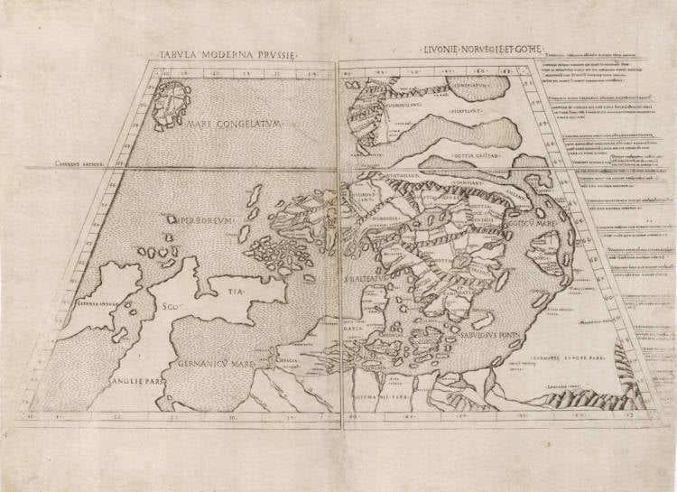
Ulm Ptolemy - Tabula Moderna Prussie Livonie Norbegie et Gottie
Certificate of Authentication
This is to certify that the item illustrated and described below is a genuine and
original antique map or print that was published on or near the given date.
Dr Leendert Helmink, Ph.D.
Cartographer
Lienhart Holle / Nicolaus Germanus
First Published
Rome, 1507
This edition
1507/08 only edition
Size
56.8 x 31.2 cms
Technique
Copperplate engraving
Stock number
19163
Condition
excellent
Description
The second map of the northern regions, and of particular interest as the first copperplate map of Scandinavia.
The map is preceded only by the corresponding map that was published in the Ulm editions of Ptolemy's Geographia in 1482/86, and upon which it is a slightly updated and altered version.
The map is of exceptional rarity, because it only appears in the final 1507/08 updated edition of the Rome Ptolemy atlas, which had first been published in 1478 and 1490 but only in the final edition of 1507/08 six "modern" maps were introduced, together with he celebrated new map of the world by Joannes Ruysch.
Condition
First and only edition, first and only state, from the 1507/1508 edition. A dark and even impression of the copperplate. Minor restorations as always. Overall in excellent collector's condition, which is unusual for maps from this extremely early work, produced more than 500 years ago, half a millenium.
Lienhart Holle / Nicolaus Germanus
"As far as cartography is concerned the printing of Ptolemy's Geographia at Ulm in 1482 (and 1486) - the first edition with woodcut maps - was an event of the greatest importance.
The edition of Ptolemy's Geographia printed at Ulm in 1482 was the first published outside Italy and the first with woodcut map; it contained 26 maps based on Ptolemy and six 'modern' maps"
(Moreland & Bannister)
"The first edition printed north of the Alps, and the first woodcut version, is more crudely executed than the previous (Ptolemy) productions. Nevertheless the bold Germanic style and the Gothic lettering have a distinctive decorative appeal, especially when combined with rich colouring. The printer was Leinhart Holle, also known for the publication of the illustrated book Buch der Weisheit.
Shortly after the publication Leinhart Holle went bankrupt. His stock was taken iover by Johann Reger who, four years later in 1486, put out a second printing of about 1000 copies. Within and between both editions variations occur in respect of the text and printed legends although the same basic blocks were used."
(Shirley)
"In 1482 Lienhart Holle in Ulm published a revised edition of Ptolemy's Geographia with the reworking of the Ptolemaic corpus by the cartographer Nicolaus Germanus Donis. The atlas included five additional "modern" maps: Italy, Spain, France, Scandinavia, and the Holy Land. The atlas would be the first book printed by Lienhart Holle, however, it would appear that the venture proved ruinously expensive and his business would go bankrupt shortly after publication. The remaining sheets, the woodblocks and the types passed to Johann Reger in Ulm, who reissued the work in 1486.
As well as the modern maps the atlas bears some other notable first. It was the first time that maps were signed by the artist responsible for the woodcutting; in this case Johannes of Armsheim, who signed the world map, and incorporated a backwards N into the woodcut text on each map. It is also the first to print the accompanying text on the verso of the map to which it refers."
(Skelton)