Leen Helmink Antique Maps & Atlases
www.helmink.com
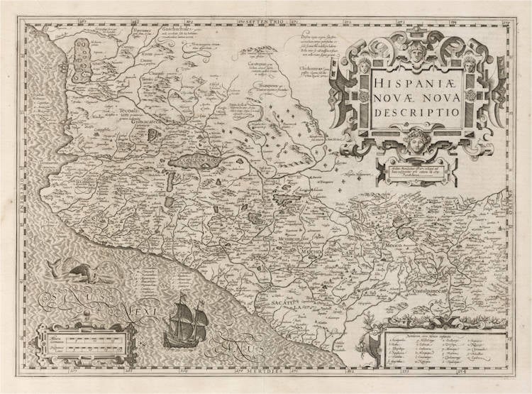
Hondius - Hispaniae Novae Nova Descriptio
Certificate of Authentication
This is to certify that the item illustrated and described below is a genuine and
original antique map or print that was published on or near the given date.
Dr Leendert Helmink, Ph.D.
Cartographer
Jodocus Hondius
First Published
Amsterdam, 1606
This edition
1623 Latin
Size
35.5 x 49.5 cms
Technique
Copper engraving
Stock number
19151
Condition
excellent
Description
Cornerstone map of Mexico by the illustrious Jodocus Hondius, one of the foremost engravers and publishers of the early 17th Century.
The map has a decorative title cartouche, with elaborate strapwork. The cartouche in the lower left gives the scale in Dutch and in Spanish miles.
The map is so densely populated with villages and cities, that many are indexed with a number or letter and placed in the Pacific. A further 26 placenames around Mexico City are indexed with a letter in the lower right cartouche. Mexico city is shown on the shores of a large lake.
The ocean, with typical silk waves engraving so typical of Jodocus Hondius, is named in swash lettering as Sinus Mexicanus and is embellished with a compass rose and with a sailing ship with flying Spanish colours.
The center of the map is full of little diamonds, indicating Spanish encampements. The northern regions are relatively unknown. In the upper left mountains are the cannibals ("Anthropophagi") and the dwellers that go naked under God. The mountains in the upper center are said to contain silver in abundance. Pearl fishing is noted on the Pacific coast.
The cartographic content of Hondius' map is based on the map first published in 1579 by the Antwerp mapmaker Abraham Ortelius. The cartographic sources for that map are unclear. Brandmair suggests Jean Duran who published a Mexico map in 1575. The numerous salt lakes produced the finest salt by means of evaporation, and much was also made of the sugar cane cultivated here.
Condition
A pristine example from the 1623 Latin edition of the atlas. Wide margins, clean and thick paper, which is highly unusual for maps from this atlas. Paper with beautiful patina of the centuries. A crisp and even imprint of the copperplate. A very desirable collector's example of this seminal map.
Jodocus Hondius (1563-1612)
Jodocus Hondius the Younger (son) (1594-1629)
Henricus Hondius (son) (1597-1651)
Jodocus Hondius the Elder, one of the most notable engravers of his time, is known for his work in association with many of the cartographers and publishers prominent at the end of the sixteenth and the beginning of the seventeenth century.
A native of Flanders, he grew up in Ghent, apprenticed as an instrument and globe maker and map engraver. In 1584, to escape the religious troubles sweeping the Low Countries at that time, he fled to London where he spent some years before finally settling in Amsterdam about 1593. In the London period he came into contact with the leading scientists and geographers of the day and engraved maps in The Mariner's Mirrour, the English edition of Waghenaer's Sea Atlas, as well as others with Pieter van den Keere, his brother-in-law. No doubt his temporary exile in London stood him in good stead, earning him an international reputation, for it could have been no accident that Speed chose Hondius to engrave the plates for the maps in The Theatre of the Empire of Great Britaine in the years between 1605 and 1610.
In 1604 Hondius bought the plates of Mercator's Atlas which, in spite of its excellence, had not competed successfully with the continuing demand for the Ortelius Theatrum Orbis Terrarum. To meet this competition Hondius added about 40 maps to Mercator's original number and from 1606 published enlarged editions in many languages, still under Mercator's name but with his own name as publisher. These atlases have become known as the Mercator/ Hondius series. The following year the maps were re-engraved in miniature form and issued as a pocket Atlas Minor.
After the death of Jodocus Hondius the Elder in 1612, work on the two atlases, folio and miniature, was carried on by his widow and sons, Jodocus II and Henricus, and eventually in conjunction with Jan Jansson in Amsterdam. In all, from 1606 onwards, nearly 50 editions with increasing numbers of maps with texts in the main European languages were printed.
(Moreland and Bannister)