Leen Helmink Antique Maps & Atlases
www.helmink.com
Solinus / Münster - ASIA MAIOR
Certificate of Authentication
This is to certify that the item illustrated and described below is a genuine and
original antique map or print that was published on or near the given date.
Dr Leendert Helmink, Ph.D.
Cartographer
Gaius Julius Solinus
First Published
Basle, 1538
This edition
1543 edition
Size
24.5 x 33 cms
Technique
Woodcut
Stock number
19139
Condition
excellent
Description
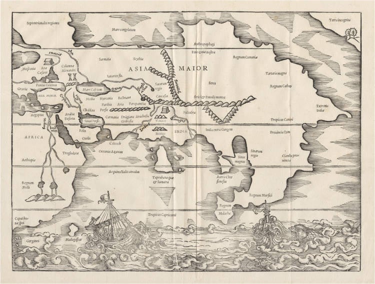
Final edition of 1543. A pristine collector's example of this seminal map.
It is Sebastian Münster's earliest map of Asia, predating his Asia map of 1540. The Münster-Solinus map is of utmost relevance to the mapping of Asia, the Indian Ocean, the Pacific Ocean and Northwest America. The map is famous for the dramatic woodcut decorations of ships being attacked by sea monsters and mermaids.
The map is an amalgamation of Ptolemaic geography, of Marco Polo's account and of the latest explorations by the Portuguese, who had discovered that the Indian Ocean was not landlocked but connected to the Atlantic and Pacific Oceans.
Bartolomeu Dias had passed the Cape of Good Hope (Caput bon.e spei) during a major storm in 1488. Above it is Regnum Melli, the Mali Empire. The sources of the Nile are in Ptolemaic fashion, and east Africe has Ptolemy's Troglodytes (Cave dwellers). The Red Sea has the port of Berenice, an important port in classical antiquity for the maritime trade between India, Ceylon, Arabia and Upper Egypt.
The Middle East is Ptolemaic, and based on the conquests and resulting discoveries of Alexander the Great in the fourth century BC. Interestingly, the legendary pillars and altars of Alexander are depicted at the Tanais River and in India, refering to the monuments that Alexander ordered to be constructed to thank the gods for having led him so far as a conqueror and as a memorial for his own accomplishments.
India follows the old Ptolemy model, between the Indus and Ganges rivers. Southern India has Bettigo mountain (Pothigay Hills). Ceylon is also modeled after Ptolemy, but is confused with Sumatra Taprobana que est Sumatra, as was often the case in early European maps. Calicuth (Kozhikode, the major trading point of Indian spices in classical antiquity and the Middle Ages) is incorrectly shown west of the Indus. The spice trade had been in the hands of the Arab and Genoese-Venetian traders. When Vasco da Gama reached it by sea via the Cape route in 1498, the Portuguese completely took over the lucrative spice trade, leading to economic disaster for the Ottomans and the Italians.
Southeast Asia has the typical Dragon's Tail, a peninsula that was first introduced in c.1490 by Martellus to replace the Ptolemy model of the region. The southern end of the peninsula has Regnum Malacha, the Sultanate of Malacca, which the Portuguese had learned of in India. They first reached Malacca in 1509 and captured it in 1511. East of the peninsula is Ciamba provincia, the Champa on the central and southern costs of modern day Vietnam.
Marco Polo's China is labeled as Regnum Cathay, the Empire of Cathay. The ancient Ptolemaic references to China are also given, namely Sinarum Regio and Seres (the Land of the Silk). North of it is Tartaria magna (Greater Tartaria). Northern Asia has the Anthropophagi (Man eaters).
Asia has a north coast, as reported by Marco Polo. A northwest passage is shown, but labeled as Mare congelatum (Frozen sea). Septentrionales regiones (Scandinavia) is grossly oversized. The Baltic and Gulf of Bothnia are very crude and inaccurate.
This Solinus edition was published in 1538 by Heinrich Petri, foremost printing-house in Basle. The text was edited and corrected by Sebastian Münster, professor in Hebrew, Latin and Greek. He also produced the maps. When teaching at the University of Heidelberg, Münster had also worked as press-corrector for Heinrich's father Adam Petri.
In 1529 Münster accepted a position at the University of Basle. In 1529, soon after his move to Basel, he left the Franciscan Order and adhered to Lutheranism; and in the following year he married Adam Petri's widow, thus gaining for himself a measure of financial security and the services of the substantial printing-house of his stepson Heinrich Petri, who was to produce most of his later works.
The Mapping of North America
In terms of cartographical detail this woodcut map is poor. Despite being of ASIA MAIOR, the top right corner depicts a north-west orientated coastline labelled Terra incognita. This is the earliest representation of the north-west coast of America on a printed map, showing only a few trees, hills and a small bay. Its existence has caused much debate, not even the cartographer is known for sure, although it is most often thought to be the work of Sebastian Münster who compiled the text of the book. The text opposite the map, on page 150, refers to this coast, 'In our days it has been explored by men', however, no such voyage is known to us today. Wagner suggests that it might be a representation of Japan, if so then this would be five years before the earliest recorded visit by a European. It also shows one of the first delineations of a strait between Asia and America some 200 years before Vitus Bering's voyage to this area. At this time there was a period of debate about a possible land mass connection to the American continent. There was a second edition of the Polyhistor in Basel, 1543. No other issues from the woodblock are known, and there is only one way to differentiate between the two issues of the map:
1538 Signature lower right, t 4
1543 No signature
(Philip Burden map 11)
Gaius Julius Solinus (3rd century A.D.)
"GAIUS JULIUS SOLINUS, Latin grammarian and compiler, probably flourished during the first half of the 3rd century A.D. He was the author of Collectanea rerum memorabilium, a description of curiosities in a chorographical framework. Adventus, to whom it is dedicated, is identified with Oclatinius Adventus, consul A.D. 218. It contains a short description of the ancient world, with remarks on historical, social, religious and natural history questions. The greater part is taken from Pliny's Natural History and the geography of Pomponius Mela. According to Mommsen, Solinus also used a chronicle (possibly by Cornelius Bocchus) and a Chorographia pliniana, an epitome of Pliny's work with additions made about the time of Hadrian. Schanz, however, suggests the Roma and Pratum of Suetonius. The Collectanea was revised in the 6th century under the title of Polyhistor (subsequently taken for the author's name). It was popular in the middle ages, hexameter abridgments being current under the names of Theodericus and Petrus Diaconus.
The commentary by Saumaise in his Plinianae exercitationes (1689) is indispensable; best edition by Mommsen (1895), with valuable introduction on the MSS., the authorities used by Solinus, and subsequent compilers. See also Teuffel, Hist. of Roman Literature (Eng. trans., 1900), 389; and Schanz, Geschichte der romischen Litteratur (1904), iv. 1. There is an old English translation by A. Golding (1587)."
(Encyclopedia Britannica).
"Caius Julius Solinus was a Roman who lived in the third or fourth century AD, possibly worked as a grammarian, and is most widely recognized for his work, the Polyhistor. Possibly written sometime in the middle of the third century, the Polyhistor, alternatively known as the Collectanea rerum memorabilium and De situ orbis, relied heavily on Pliny's Natural History as well as Pomponius Mela's De situ orbis. The work touches on the natural history and geography of the regions known to the Roman Empire, as well as religious and social matters. Solinus's Polyhistor remained popular through the Middle Ages and Renaissance, particularly for its geographical content. The Polyhistor was first translated into English in 1587 by Arthur Golding."
(Clements Library)