Leen Helmink Antique Maps & Atlases
www.helmink.com
Münster / Ptolemy - TABVLA ASIAE VIII
Certificate of Authentication
This is to certify that the item illustrated and described below is a genuine and
original antique map or print that was published on or near the given date.
Dr Leendert Helmink, Ph.D.
Cartographer
Sebastian Münster
First Published
Basle, 1540
This edition
1552
Size
25.0 x 34.4 cms
Technique
Woodcut
Stock number
19119
Condition
mint
Description
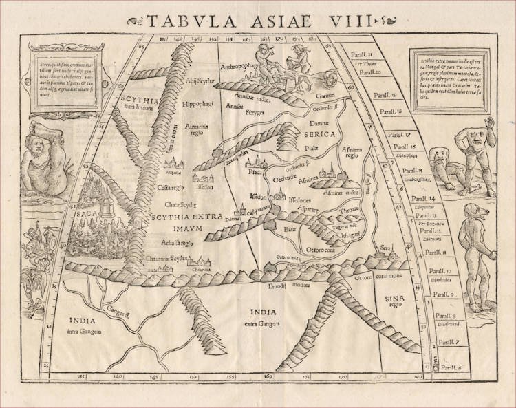
One of the earliest maps of the Far East and China, according to the Roman/Greek cartographers from classical antiquity.
A pristine example from the rare 1552 fourth and final edition of Münster's Geographia.
This is Sebastian Münster's woodcut map of Ptolemy's eighth map of Asia, covering Scythia beyond the Imaus mountains, Serica, and Sina regio, the eastern most lands known to the ancient Greeks. The area corresponds to the Asian steppes and the mysterious land that supplies the silk ("Serica", i.e. China). SINA regio is situated in the lower right, corresponding also to China. The northeastern part of India with the Ganges River is in the lower left. The legendary Gates of Alexander the Great are depicted at the left.
The geographical contents is based on Ptolemy's Geography that was published around 150 AD in Alexandria, and is the oldest surviving European representation of the region before the 16th Century explorers charted it.
It is noteworthy that where nearly all other Ptolemy maps of Münster use Ptolemy's canonical or trapezoid projection, which is relatively simple to draw. Here however, Münster has chosen Ptolemy's second "cloak" (chlamys) or 'homeotheric' projection, which provides a far more satisfactory image of the earth's shape, but is also much harder to contruct mathematically, because both the lines of latitude as well as the lines of longitude are curved.
Sebastian Münster has added decorations in and around the map that are not from Ptolemy but that go back to other Greek sources.
In the north, the map is decorated with cannibal scenery of "Anthrophagi" (man-eaters). For sources of this see e.g. Pliny Historia Naturalis VII.2: ".. drink out of human skulls and use the scalps with the hair on as napkins hung round their necks ..". The horse eaters (Hippophagi) and lice eaters are nearby.
Around the map are depictions of mythical creatures:
"umbrella-foot" man (Pliny VII.2: ".. because in the hotter weather they lie on their backs on the ground and protect themselves with the shadow of their feet .."),
people with dog's head (Strabo 1.2: ".. men who are half dog .."),
creatures having no heads but face on their breast (Strabo 1.2: ".. men with eyes in their breasts ..").
and the small pygmies, who grow pepper in great abundance, and are in continual battle with the cranes (after d’Ailly, Ymago mundi, Chap. 16).
The back of the map has decorative woodcuts that are attributed to the great artist Hans Holbein the Younger, a close friend and colleague of Sebastian Münster.
Antique Maps - A Collector's Guide
To enhance Tabula VIII of Ptolemy's Asia, Münster borrowed creatures from medieval legend. Among them is one of those curiously afflicted people of India with only one leg. The size of his foot compensates, however; it makes a good sunshade. There is a cruelly taloned Scythian gryphon, here menaced by hunters. And there are a headless race of men with faces set into their chests and hill-men with dogs' heads who 'barked for speech'.
On the map itself to the North of Serica - the Land of Silk - an Anthropophagi couple prepare a meal. The presence of Serica with Sera (modern Sian), the chief city along the silk routes, suggests that Ptolemy gleaned information from traders.
(Tooley & Bricker).
Sebastian Münster (1489-1552)
Following the various editions of Waldseemüller's maps, the names of three cartographers dominate the sixteenth century: Mercator, Ortelius and Münster, and of these three Münster probably had the widest influence in spreading geographical knowledge throughout Europe in the middle years of the century.
His Cosmographia, issued in 1544, contained not only the latest maps and views of many well-known cities, but included an encyclopaedic amount of detail about the known - and unknown - world and undoubtedly must have been one of the most widely read books of its time, going through nearly forty editions in six languages.
An eminent German mathematician and linguist, Münster became Professor of Hebrew at Heidelberg and later at Basle, where he settled in 1529. In 1528, following his first mapping of Germany, he appealed to German scholars to send him "descriptions, so that all Germany with its villages, towns, trades, etc. may be seen as in a mirror", even going so far as to give instructions on how they should "map" their own localities. The response was far greater than expected and such information was sent by foreigners as well as Germans so that, eventually, he was able to include many up-to-date, if not very accurate, maps in his atlases.
He was the first to provide a separate map of each of the four known Continents and the first separately printed map of England. His maps, printed from woodblocks, are now greatly valued by collectors. His two major works, the Geographia and the Cosmographia were published in Basle by his step-son, Henri Petri, who continued to issue many editions after Münster's death of the plague in 1552.
(Moreland & Bannister).
The remaining modern maps, [...], are all drawn on a plane projection, undergraduated, without scales, and variously oriented with north, south, east or west at the top, "without the excuse of topographical necessity", as Nordenskjöld severely remarks. In spite of these and other cartographic defects, they constitute an important corpus of geographical knowledge and interpretation; Münster was the first atlas-maker to furnish separate maps of the four continents then known; and for England, Scandinavia and southern Germany, eastern Europe and America he brought recent and significant representations into general currency.
(Skelton).
The Cosmographia of Sebastian Münster must rank as the greatest geographical compendium of the period - an immensely detailed work illustrated with woodcut portraits, scenes, town plans and panoramas, and maps. Born in 1488, Münster was a Fransiscan who became Professor of Hebrew at Heidelberg and later at Basle, where he taught Hebrew and, amongst other works, published the first German translation of the Bible from Hebrew. In 1540 his edition of Ptolemy's Geographia was published, followed in 1544 by the Cosmographia Universalis. Together these ran to over 35 editions published mostly in Basle in Latin, German, French and Italian versions. Münster's particular cartographic importance lies in the number of 'new' maps he introduced and, above all, in the innovative, separate mapping of each of the four continents. The map of the Americas is not only the first map to show the Western Hemisphere separately, but is also the first to show North and South America joined together.
(Potter p38).
Sebastian Münster was raised as a Franciscan monk, converted to Lutheranism, taught Hebrew at Heidelberg and Basle, and was proficient in Greek and some Asian tongues. He died of the plague in 1552. First published in 1540, his atlas was the first to contain separate maps of each of the four continents.
(Suárez).
In 1540 Sebastian Münster, who was to become one of the most influential cartographers in the sixteenth century, published his edition of Ptolemy's Geographia with a further section of modern, more up-to-date maps. He included for the first time a set of continental maps, the America was the earliest of any note. Münster studied Hebrew at Heidelberg and was a scholar of geography, writing amongst other works the Polyhistor.
He was one of the first to create space in the woodblock for the insertion of place-names in metal type. The map's inclusion in Münster's Cosmography, first published in 1544, sealed the fate of "America" as the name for the New World. The book proved to be very popular, there being nearly forty editions during the following 100 years.
(Burden).