Leen Helmink Antique Maps & Atlases
www.helmink.com
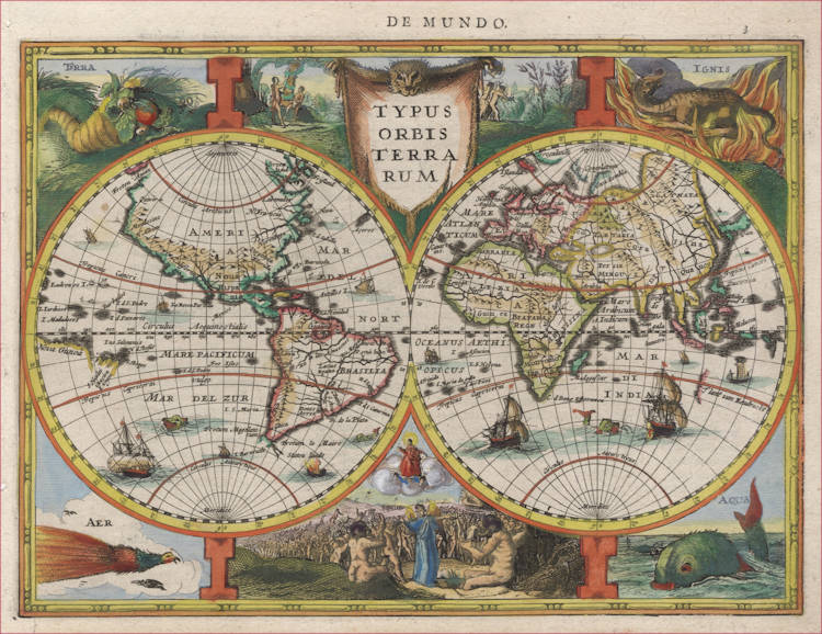
Jodocus Hondius II - Typus Orbis Terrarum
Certificate of Authentication
This is to certify that the item illustrated and described below is a genuine and
original antique map or print that was published on or near the given date.
Dr Leendert Helmink, Ph.D.
Cartographer
Jodocus Hondius the Younger
First Published
Amsterdam, 1630
This edition
1632 Latin edition
Size
26.0 x 19.0 cms
Technique
Copper engraving
Stock number
19107
Condition
mint
Description
Summary
This small double hemisphere map is the first published map in an atlas to depict any part of Australia. The 1616 discoveries by the Dutchman Hartog in the ship Eendracht are charted on Australia's west coast.
(Simon Dewez}
Medium-size map of the world from the 1630 French Cloppenburg edition of the Atlas Minor made by Jodocus Hondius the younger. A reduced version of his legendary 1621-1624 folio size map of the world, which was the first map to show any of the Dutch discoveries of Australia.
The two hemispheres are surrounded by allegoric representations of the four elements, a popular motif in Dutch graphic art. It expresses the need of mankind to establish order in the world. Dating back to ancient Greek science and philosophy, the four classical elements were considered to form the structure of the universe. A relation was assumed between the four elements and the seasons. Spring corresponded to Air, Summer to Fire, Autumn to Earth and Winter to Water.
Center top are the Temptation and the Expulsion of Adam and Eve from the Garden of Eden. Center bottom is the Last Judgement.
Together the decorations depict a cosmic order in which everything is related in one global harmony.
Australia Unveiled
This map is part of the French Cloppenburg edition of the "Atlas Minor" of 1630. While in the other editions of this atlas the idea of a great unknown south-land traversing both hemispheres is retained, the French and Latin edition show a quite different picture of the world. The unknown southern continent has disappeared altogether and south of Java the west-coast of Java emerges, here named T lant van Eendracht.
(Gunter Schilder).
The Mapping of the World
THE FOURTH and last series of reduced versions of Mercator's atlas was published by the Amsterdam bookseller Jan Cloppenburgh in 1630. The maps were engraved by Pieter van den Keere and are larger than the preceding examples.
The two hemispheres of the world are supported on blunt pillars. The elements Earth, Fire, Air, Water are illustrated respectively in the corners of the map by a cornucopia, a chameleon, a bird of paradise and a whale; and between the hemispheres are scenes from the Garden of Eden and the Last Judgement. Initially Cloppenburgh included part of the Australian coastline under the name t’Land van Eendracht: the first depiction of Australia in an atlas.
The map in its first state was used for editions of Cloppenburgh's Atlas in 1631, 1632 and 1636. When reprinted by Jansson's heirs in 1673 and 1676 Australia was redrawn under the heading Na Hollandia vulgo t'Land van Eendracht with t’Land van A V. Diemen also marked to the south together with new islands in the south Indian and Atlantic oceans.
BL Maps C.3.b.3 and LC 440 (1628); Kansas University Library, Summerfield D 437 (second state in book by Gregorio Leti, 1689).
Koeman, Me. 198; Schilder, Map 33; Weinreb & Douwma, Catalogue 7, 1971, item 6.
(Rodney Shirley)
CLOPPENBURGH, Jan 1630 (1631)
TYPUS ORBIS TERRARUM
26.0 x 19.0 cms
Strong fine colour. Fine condition.
First published in ‘Gerardi Mercatoris Atlas...auctus Studio Jodoci Hondij’ Amsterdam 1631.
The first published map in an atlas to depict any part of Australia. The 1616 discoveries by the Dutchman Hartog in the ship the Eendracht are charted on Australia's west coast.
This decorative, double hemisphere world map appears for the first time in Jodocus Hondius' reduced version of Mercator's atlas, in the edition edited and published by Jan Cloppenburgh in 1631. According to Shirley, the 1630 edition of the atlas (which does not contain the map) was the fourth and last of a series of reduced versions of the Mercator atlas. Cloppenburgh's map is of significance, as for the first time in an atlas, a map charts a small section of the West Australian coastline with the notation ‘t'Land van Eendracht' indicating Hartog's 1616 discoveries.
While taking the newly discovered Dutch sailing route from Capetown to the Sunda Straits and onto the East Indies, via more southerly latitudes, Hartog miscalculated the longitude and overshot the mark where he was to turn north, landing instead on Australia's west coast.
Although the map itself was engraved in 1630, the same year as the famous world map by Jodocus Hondius' brother Henricus, it didn't appear in the atlas until 1631, shortly before Henricus's map appeared. Only a handful of maps show earlier representations of any part of Australia. Only three of these - Jodocus Hondius' rare 1625 world map, the Van Langren's fragment and the title page of Journael van de Nassausche Vloot -1626, show an earlier representation of Australia's west coast. However unlike Cloppenburgh's map, none of these were actually published in an atlas.
The Cloppenburgh map features allegorical figures in the four corners representing the elements (earth, wind, fire and water) as well as scenes from the Garden of Eden and the Last Judgement, which adorn the borders.
In 1673 & 1676, the Jansson heirs produced their own version of the map. Although essentially the same, in these later editions the map has now been updated geographically to take into account the 1642-44 discoveries by Tasman in Australia and New Zealand.
Schilder map 33, illust. p.309; Koeman, Me.198; Blaxland 1990 cat. map 18; Shirley 334, p.252 (Jansson edit).
(Simon Dewez)
MERCATOR'S ATLAS BY JAN EVERTSZ. CLOPPENBURCH
The edition of Mercator's Atlas published by Jan Evertsz. Cloppenburch was a competitive edition. Its newly engraved maps were of a size (c. 19 x 25 cm) that fell in between the folio maps in the Mercator-Hondius Atlas (c. 35 x 50 cm) and the Atlas Minor (c. 15 x 20 cm). Most of the maps were engraved (anew) by Pieter van den Keere.
On 30 March 1630, an advertisement was placed in Jan van Hilten's Courante uyt Italien ende Duytschlandt, &c.: “Ian E. Cloppenburgh sal uytgeven een nieuwe Atlas, G. Mercatoris in 't Fransch, wesende alle nieuwe Caerten, ende is vermeerdert met een Appendix van nieuwe Caerten ende Beschrijvinge die voor desen in gheen andere gheweest zijn.” [= Jan E. Cloppenburch will publish a new atlas of G. Mercator in the French language, being all new maps and enlarged with an appendix of new maps and descriptions never seen before]. On 24 April 1632, the Latin edition was advertised in the same newspaper.
Cloppenburch's Atlas is dedicated to the States General of the United Provinces and Prince Frederik Hendrik of Orange (1584-1647), stadhouder of Holland etc. The Cloppenburch edition was continued for a couple of years but seems to have been suppressed after 1636. It was continued after 1673 by the Janssonius heirs.
(van der Krogt).
Jodocus Hondius (1563-1612)
Jodocus Hondius II (son) (1594-1629)
Henricus Hondius (son) (1597-1651)
"Jodocus Hondius the Elder, one of the most notable engravers of his time, is known for his work in association with many of the cartographers and publishers prominent at the end of the sixteenth and the beginning of the seventeenth century.
A native of Flanders, he grew up in Ghent, apprenticed as an instrument and globe maker and map engraver. In 1584, to escape the religious troubles sweeping the Low Countries at that time, he fled to London where he spent some years before finally settling in Amsterdam about 1593. In the London period he came into contact with the leading scientists and geographers of the day and engraved maps in The Mariner's Mirrour, the English edition of Waghenaer's Sea Atlas, as well as others with Pieter van den Keere, his brother-in-law. No doubt his temporary exile in London stood him in good stead, earning him an international reputation, for it could have been no accident that Speed chose Hondius to engrave the plates for the maps in The Theatre of the Empire of Great Britaine in the years between 1605 and 1610.
In 1604 Hondius bought the plates of Mercator's Atlas which, in spite of its excellence, had not competed successfully with the continuing demand for the Ortelius Theatrum Orbis Terrarum. To meet this competition Hondius added about 40 maps to Mercator's original number and from 1606 published enlarged editions in many languages, still under Mercator's name but with his own name as publisher. These atlases have become known as the Mercator/ Hondius series. The following year the maps were reengraved in miniature form and issued as a pocket Atlas Minor.
After the death of Jodocus Hondius the Elder in 1612, work on the two atlases, folio and miniature, was carried on by his widow and sons, Jodocus II and Henricus, and eventually in conjunction with Jan Jansson in Amsterdam. In all, from 1606 onwards, nearly 50 editions with increasing numbers of maps with texts in the main European languages were printed."
(Moreland and Bannister)