Leen Helmink Antique Maps & Atlases
www.helmink.com
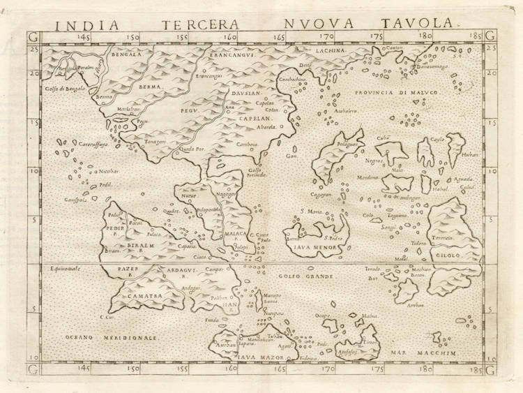
Ruscelli / Gastaldi - India Tercera Nuova Tavola
Certificate of Authentication
This is to certify that the item illustrated and described below is a genuine and
original antique map or print that was published on or near the given date.
Dr Leendert Helmink, Ph.D.
Cartographer
Girolamo Ruscelli
First Published
Venice, 1561
This edition
Venice, 1574
Size
17.6 x 24.2 cms
Technique
Copper engraving
Stock number
19070
Condition
pristine
Description
Highly distorted and inaccurate map by Girolamo Ruscelli after Jacopo Gastaldi's 1548 miniature map of this region. A cornerstone map of the area that introduces new knowledge from the Portuguese explorations.
Condition
Thick paper with wide margins. Good and even impression of the copper plate. No restorations or imperfections. A pristine collector's copy of this seminal map.
Early Mapping of Southeast Asia
Gastaldi's 1548 India Tercera Nova Tabula
Although the maps in Gastaldi's issue of Ptolemy's Geographia are relatively small, they were handsomely engraved on copper, allowing more detail and clarity than their woodcut predecessors. The medium of copperplate had been virtually abandoned by mapmakers for four decades, since the 1507-08 Rome edition of Ptolemy's Geographia.
Gastaldi retains Ptolemy's full complement of maps, including the Ptolemaic rendering of Southeast Asia, which by this time was of no merit except as a testimonial to the reverence in which classical writings were still held. He adds, however, a fine new map of the Southeast Asian mainland and islands, entitled India Tercera Nova Tabula, as it was the third of his atlas 'new' maps. It was extracted from a world map Gastaldi had made in 1546, and was a major contribution to the mapping of the region.
Although this map was published in only one issue in its original form, it was copied by other mapmakers and via such copies, it outlived its relevancy even longer than the map by Münster. In 1561, the map was re-engraved, roughly twice the size, for a new edition of Ptolemy by Girolamo Ruscelli, in which form it was re-published several times up until 1599. It was also re-engraved in a smaller format for the isolario of Tomaso Porcacchi, which was published in several editions from 1572 through to 1686.
The 1548 map from the Geografia relies far more heavily on data from the Magellan voyage than either Gastaldi's 1554 or 1561 maps of Southeast Asia, particularly in relation to the Philippines. But it also records certain features — notably, a remarkably accurate depiction of Palawan and a ‘Gunung Api' (a small volcanic island) — which cannot be attributed to Magellan's discoveries and suggest that Gastaldi had access to advanced Portuguese sources.
(Thomas Suárez, Early Mapping of Southeast Asia)
Girolamo Ruscelli (1504-1566)
Girolamo Ruscelli (1504 Viterbo -1566 Venice), an Italian Alchemist, Physician and cartographer, was editor of a revised and expanded Italian edition of Ptolemy's 'Geographia', published as 'La Geografia di Claudio Tolomeo. The newly engraved maps were based, generally, on those compiled by Giacomo Gastaldi for the Venice miniature atlas edition of 1548.
Ruscelli's atlas was issued several times between 1561 and 1599 by the following publishers
- Venice, Vincenzo Valgrisi, 1561
- Venice, Vincenzo Valgrisi, 1562
- Venice, G. Zileti, 1564
- Venice, G. Zileti, 1574
- Venice, Heirs of Melchior Sessa, 1598-99
The Ruscelli and Gastaldi atlases were the most comprehensive atlases produced between Martin Waldseemüller's 'Geographia' of 1513, and Abraham Ortelius 'Theatrum' of 1570. The significance of the Gastaldi and Ruscelli atlases cannot be overestimated. They defined the known geography of the world for decades. These atlases also reintroduced the use of copper engraving into the service of cartography, which was dominated by woodcut printing after several not very succesful attempts to print from copper in the 15th century. The Gastaldi and Ruscelli atlases proved that maps could be beautifully engraved on copper. As it was a harder material than wood, it was harder to engrave but also gave the ability to render much more detail. The Gastaldi and Ruscelli atlases marked a turning point in the history of cartography, from then on the majority of cartographic works used this medium.
"Ruscelli was editor of a revised and expanded edition of Ptolemy's Geographia which was issued in Venice several times between 1561 and the end of the century.
The newly angraved maps were based, generally, on those compiled by Giacomo Gastaldi for the Venice edition of 1548."
(Moreland & Bannister).