Leen Helmink Antique Maps & Atlases
www.helmink.com
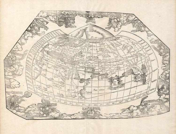
Fries / Waldseemüller / Ptolemy - Generale Ptho [lemaeus]
Certificate of Authentication
This is to certify that the item illustrated and described below is a genuine and
original antique map or print that was published on or near the given date.
Dr Leendert Helmink, Ph.D.
Cartographer
Laurent Fries
First Published
Strassburg, 1522
This edition
1525 second edition
Size
cms
Technique
Woodcut
Stock number
19052
Condition
pristine
Description
Fries' map is a reduced copy of Waldseemüller's 1513 Ptolemy map of the world. Somewhat surprisingly, and unrecorded in the literature, Waldseemüller had erroneously reversed the eastern and western winds from classical antiquity. Fries took over that mistake in his first 1522 edition of the map, but corrected it when adding the decorated border with the heads of the winds in the 1525 edition. It is also noteworthy that where Waldseemüller uses Ptolemy's canonical projection, which is relatively simple to draw, Fries has chosen Ptolemy's second "cloak" (chlamys) projection, which provides a far more satisfactory image of the earth's shape, but is also much harder to contruct, because both the lines of latitude as well as the lines of longitude are curved.
This example from the early 1525 Strassburg edition. In this edition the map has no title, therefore the title we use is the one used in the first 1522 edition. The woodcut decorations around the map are attributed to Albrecht Dürer, who also made the famous woodcut print of the armillary sphere in this atlas.
Condition
Strong and early imprint of the woodblock. Mint collector's condition.
The Mapping of the World
"Waldseemüller's Ptolemaic map of 1513 has been redrawn and reduced in size in this publication by Laurent Fries, geographer and physician, The printer was Johann Grüninger.
The [1535] Lyons edition was printed by Melchior and Gaspar Treschel; it was ordered to be burnt by Calvin because of alleged heresy and is therefore rare."
(Shirley).
Fries' version of Waldseemüller's Ptolemy's map of the world, which had been amended with a crude Scandinavian peninsula outside the traditional Ptolemy map.
"Laurent Fries' reduced copy of Waldseemüllers' 1513 Ptolemy world map. Slight emendations have been applied to Ptolemy: the land which to the south of the Indian ocean unites Africa and Asia is left out."
(Nordenskiöld).
"Since many copies (of the book) were burnt by order of Calvin, it has become rare."
(Mortimer).
Waldseemüller's 1513 Ptolemy map of the World
Waldseemüller's 1513 Strassburg Ptolemy is the most important edition of the Geographia on account of the many new regional maps it contains. Preparatory work was begun in about 1505 by Martin Waldseemüller, scholar-geographer of the small town of St. Dié in Lorraine, together which his associate Mathias Ringmann. Waldseemüller is believed to have incised many of the maps himself; all are firm distinctive woodcuts. By 1507 much progress had been made but - possibly because of his large world map commitments - the project was delayed and was not completed until 1513 under the editorship of Jacob Eszler and Georg Ubelin. The printer was Johann Schott, and the work, the first modern atlas, bears a dedication to the Emperor Maximilian. There are two noteworthy world maps: a Ptolemaic one and a modern one showing the latest discoveries.
The Ptolemaic world map is a bold woodcut on the traditional modified conical projection with all regions above 65° north (just north of the British Isles) covered by the inscription Mare Congelatum or 'Frozen Sea'. The continents represented follow the Ptolemaic outline although the wood cutter has not felt he could sustain the concept of a land-locked Indian Ocean and so has omitted the strip of land normally linking southern Africa to Asia. The map itself is bordered by the usual markings of latitude and longitude and the climates. Outside this is a vigorous surround of clouds with twelve characteristic windheads representing the classical winds blowing from each direction. Visually, it is one of the most attractive Ptolemaic world maps produced.
(Rodney Shirley, The Mapping of the World Map 34).
Laurent Fries (c.1490-c.1532)
Laurent Fries (Laurentius Frisius), born in Mulhouse in Burgundy, travelled widely, studying as a physician and mathematician in Vienne, Padua, Montpellier and Colmar before settling in Strassburg. There he is first heard of working as a draughtsman on Peter Apian's highly decorative cordiform World Map, published in 1520. Apian’s map was based on Waldseemüller's map of 1507 which no doubt inspired Fries's interest in the Waldseemüller Ptolemy atlases of 1513 and 1520 and brought him into contact with the publisher, Johannes Grüninger. It is thought that Grüninger had acquired the woodcuts of the 1520 edition with the intention of producing a new version to be edited by Fries. Under his direction the maps were redrawn and although many of them were unchanged, except for size, others were embellished with historical notes and figures, legends and the occasional sea monster. Three new maps were added.
There were four editions of Fries' reduced sized re-issue of Waldseemüller's Ptolemy atlas:
1522 Strassburg: 50 woodcut maps, reduced in size, revised by Laurent Fries (Laurentius Frisius) and included the earliest map showing the name ‘America' which is likely to be available to collectors
1525 Strassburg: re-issue of 1522 maps
1535 Lyon: re-issue of 1522 maps, edited by Michael Servetus who was subsequently tried for heresy and burned at the stake in 1553, ostensibly because of derogatory comments in the atlas about the Holy Land – the fact that the notes in question had not even been written by Servetus, but were copied from earlier editions, left his Calvinist persecutors unmoved
1541 Vienne (Dauphiné): re-issue of the Lyon edition - the offensive comments about the Holy Land have been deleted
(Moreland and Bannister)