Leen Helmink Antique Maps & Atlases
www.helmink.com
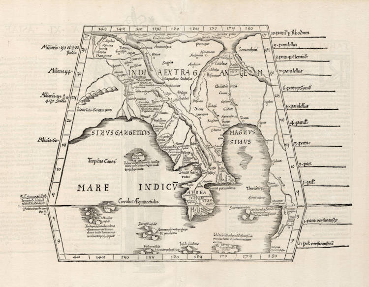
Fries / Waldseemüller / Ptolemy - Tabula Undecima (XI) Asiae
Certificate of Authentication
This is to certify that the item illustrated and described below is a genuine and
original antique map or print that was published on or near the given date.
Dr Leendert Helmink, Ph.D.
Cartographer
Laurent Fries
First Published
Strassburg, 1522
This edition
1525 second edition
Size
28.3 x 40.2 cms
Technique
Woodcut
Stock number
19041
Condition
pristine
Description
Laurent Fries' version of Ptolemy's eleventh map of Asia, covering the "southeastern corner" of the known world. The map shows "India beyond the Ganges" and covers the eastern part of the Indian Ocean, prominently showing the Malaysian Peninsula or the Golden Chersonese as the Greeks called it.
Fries' map is a reduced copy of Waldseemüller's eleventh Ptolemy map of Asia, with the Malaysian peninsula, the islands of Maniolae (by some identified with Manilla), and the legendary huge sea port of Cattigara, possibly corresponding to Canton. It is furthest places in the Far East that the Greek merchants visited for trading.
This example from the early 1525 Strassburg edition. The woodcut decorations on the back are attributed to Albrecht Dürer, who also made the famous woodcut print of the armillary sphere in this atlas.
Condition
Strong and early imprint of the woodblock. Mint collector's condition.
Laurent Fries (c.1490-c.1532)
Laurent Fries (Laurentius Frisius), born in Mulhouse in Burgundy, travelled widely, studying as a physician and mathematician in Vienne, Padua, Montpellier and Colmar before settling in Strassburg. There he is first heard of working as a draughtsman on Peter Apian's highly decorative cordiform World Map, published in 1520. Apian’s map was based on Waldseemüller's map of 1507 which no doubt inspired Fries's interest in the Waldseemüller Ptolemy atlases of 1513 and 1520 and brought him into contact with the publisher, Johannes Grüninger. It is thought that Grüninger had acquired the woodcuts of the 1520 edition with the intention of producing a new version to be edited by Fries. Under his direction the maps were redrawn and although many of them were unchanged, except for size, others were embellished with historical notes and figures, legends and the occasional sea monster. Three new maps were added.
There were four editions of Fries' reduced sized re-issue of Waldseemüller's Ptolemy atlas:
1522 Strassburg: 50 woodcut maps, reduced in size, revised by Laurent Fries (Laurentius Frisius) and included the earliest map showing the name ‘America' which is likely to be available to collectors
1525 Strassburg: re-issue of 1522 maps
1535 Lyon: re-issue of 1522 maps, edited by Michael Servetus who was subsequently tried for heresy and burned at the stake in 1553, ostensibly because of derogatory comments in the atlas about the Holy Land – the fact that the notes in question had not even been written by Servetus, but were copied from earlier editions, left his Calvinist persecutors unmoved
1541 Vienne (Dauphiné): re-issue of the Lyon edition - the offensive comments about the Holy Land have been deleted
(Moreland and Bannister)