Leen Helmink Antique Maps & Atlases
www.helmink.com
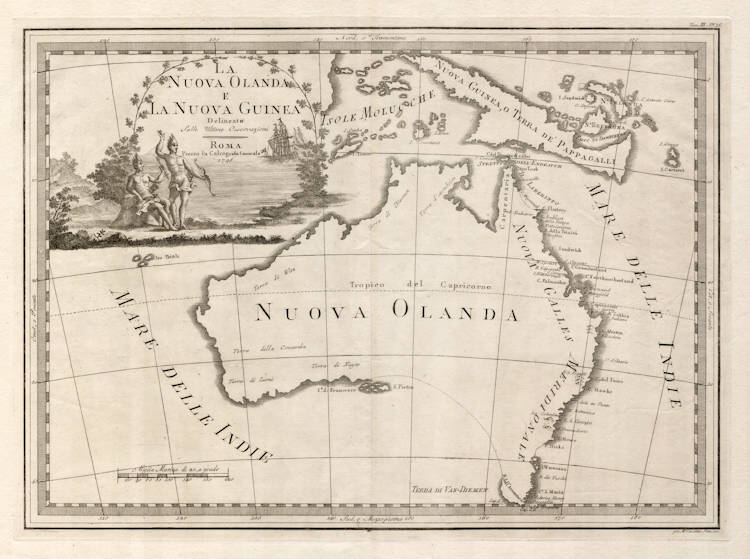
Cassini - LA NUOVA OLANDA E LA NUOVA GUINEA Delineate Sulle Ultime Osservazioni, ROMA. Presso la Calcografia Camerale 1798.
Certificate of Authentication
This is to certify that the item illustrated and described below is a genuine and
original antique map or print that was published on or near the given date.
Dr Leendert Helmink, Ph.D.

Cartographer
Cassini
First Published
Rome, 1798
This edition
Size
48.5 x 35.0 cms
Technique
Copper engraving
Stock number
19008
Condition
mint
Description
Cassini's rare, decorative map of Australia and New Guinea showing the results of Cook's voyage along the east coast of Australia.
Condition
A pristine example. Strong and even imprint of the copperplate. Second state of two. Thick clean paper with ample margins all around. Mint collector's example.
The Printed World IV
Following the much publicised, landmark discovery of Australia's east coast by Capt. James Cook in 1770, mapmakers around the world were quick to incorporate those discoveries onto their maps. Ironically, only a small handful of rare maps from that lot, concentrate on the whole Australian continent itself. Cassini's highly decorative map of Australia, is only the third such map (following the very scarce 1779 pocket atlas map by de Baillou, and Eden's rare 1787 map). It charts the discoveries made by Cook on the east coast of Australia, and labels many of them in Italian. The map features at the top left, a decorative vignette with natives and a ship. Australia is named Nuova Olanda and New Guinea is named Nuova Guinea, O Terra de Pappagalli - land of parrots. The Indian Ocean (Mare delle Indie) is shown to be on both sides of Australia.
This is the second state of Cassini's map and differs from the first in one small detail - rafia is inserted after Calcog. in the title, and Camerale has been re-engraved and moved along slightly to incorporate the addition.
Cassini's atlas is noted for its beauty and rarity, with many of its maps having highly decorative vignetted cartouches such as this one.
(Simon Dewez)