Leen Helmink Antique Maps & Atlases
www.helmink.com
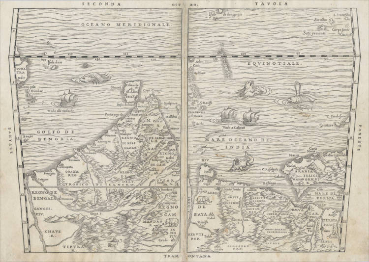
Ramusio / Gastaldi - Seconda Tavola
Certificate of Authentication
This is to certify that the item illustrated and described below is a genuine and
original antique map or print that was published on or near the given date.
Dr Leendert Helmink, Ph.D.
Cartographer
Giovanni Ramusio
First Published
Venice, 1554
This edition
1554 first edition
Size
28.5 x 38.0 cms
Technique
Woodcut engraving
Stock number
18946
Condition
excellent
Description
South-oriented map of the Indian Ocean, extending from western Sumatra through the Arabian Gulf. Two sailing ships and many sea monsters. The map was published by Giovanni Battista Ramusio in Volume I of his 'delle Navigationi et Viaggi', "the first great collection of travel literature" (Skelton). Author of the map is the famous cartographer Giacomo Gastaldi, also from Venice and a close friend of Ramusio.
1554 FIRST EDITION. Woodcut State I.
Of highest significance and rarity.
The first accurate map of the northern parts of the Indian Ocean and the Arabian Gulf, showing Portuguese India, with first Calicut and later Goa as their political, military and episcopal center. The map covers he sea routes from eastern Africa (Socotra Island), the Arabian Peninsula, the Arabian Gulf (with Bahrein and an early depiction of an Emirates port city, the Portuguese strongholds of Hormuz, Diu, Goa and Cochin. The Maldivas are shown, as well as the little island of Diego Garcia. Ceylon is accurately positioned, With Adam's Peak marked. The Indian peninsula is decorated with elephants, a lion and a hunting scene. In the east the map extends to the Gulf of Bangala with the Ganges estuary and to northern Sumatra, with the port of Atjeh (Pedir) and the Nocobar islands.
Portuguese caracks are depicted full sail on their way to Calicut (Vado a Calicut) and en route to the Spice Islands (Vado alle Moluche). The Indiamn Ocean is filled with many sea monsters.
The map is simply titled "SECONDA TAVOLA" (Second Map), from Ramusio's First Volume of his collection of Voyages. The map is oriented with south at the top, as Europeans would often draw it from their perspective of the sea routes to the east. Outside the map, the directions of the compass are given as directions of the Italian winds, as was customary in the early days of exploration: OSTRO (South), PONENTE (West), TRAMONTANA (North), and LEVANTE (East).
The map uses Prtolemy;s old trapezoid projection, in a crude effort to reflect the curvature of the earth. The equator (EQUINOTIALE) has marks running from 85-145 degrees longitude. North of the equator (so the lower part of the map), the latitude marks go up to 35 degrees north, and the Indian Ocean is named MARE OCEANO DE INDIA (Indian Ocean). South of the equator (so the upper part of the map), the latitude marks go up to 9 degrees south, and the Indian Ocean is named OCEANO MERIDIONALE (Southern Ocean). The Portuguese sea route to the Indies was to sail along the coasts of Africa and Asia, using the monsoon seasons that the Arabs traditionally used. The routes to the Indies via the southern Indian Ocean were not used until the Dutch VOC entered the Indian Ocean theater half a century later.
According to Ramusio's introduction to the book, the maps are the work of his friend Giacomo Gastaldi, the greatest of all Italian mapmakers.
Condition
Verso blank. Overall and excellent collector's copy.
Giovanni Baptista Ramusio (1485-1557)
Ramusio is the first overview work of voyages of discovery. It was first published in 1550 (Volume 1, but not with maps until 1554), 1559 (Volume 2) and 1557 (Volume 3). All were published in Venice.
"Though he himself traveled little, Ramusio published Navigationi et Viaggi ("Navigations and Travels"); a collection of explorers' first-hand accounts of their travels. This was the first work of its kind. "Delle navigationi et viaggi" (Navigations and Travels) is a collection of explorer's first-hand accounts of their travels. It was the first work of its kind. It included the accounts of Marco Polo, Niccolò Da Conti, Magellan, Alvar Nuñez Cabeza de Vaca and Giosafat Barbaro, as well as the Descrittione dell’ Africa. The description of China contains the first reference in European literature to tea. He also published an excerpt of Tomé Pires' work on the Indies, which had come into his hands, though he did not know the name of its author. The first volume was published in 1550, quickly followed by the third volume in 1556. Publication of the second volume was delayed because the manuscript had been destroyed in a fire before being sent to the printer, and was finally published in 1559, two years after its compiler's death. Navigationi et Viaggi was translated into several languages and reprinted a number of times, indicating how popular such books were becoming on the Continent. It paved the way for a slew of other such works, including those of Richard Hakluyt."
(Wikipedia)