Leen Helmink Antique Maps & Atlases
www.helmink.com
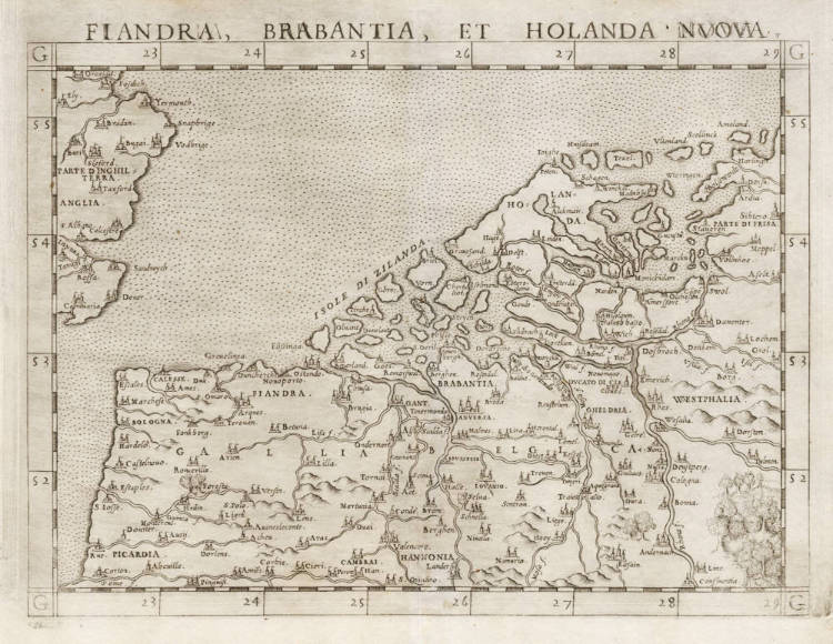
Ruscelli / Gastaldi - Fiandra, Brabantia et Holanda Nuova
Certificate of Authentication
This is to certify that the item illustrated and described below is a genuine and
original antique map or print that was published on or near the given date.
Dr Leendert Helmink, Ph.D.
Cartographer
Girolamo Ruscelli
First Published
Venice, 1561
This edition
1562 first state
Size
18.1 x 24.7 cms
Technique
Copper engraving
Stock number
18866
Condition
excellent
Description
Ruscelli's enlarged version of Gastaldi's 1548 miniature map of the Low Countries, the first map of the area and a cornerstone map for collectors. First state, with the copperplate running off the top of the map.
At the time, the area was a tiny province of the mighty Spanish Empire of Charles V, who was succeeded in 1556 by his son Philip II. In 1568, the Seventeen Provinces of what are today the Netherlands, Belgium and Luxemburg revolted against Philips II, resulting in the successful Dutch War of Independence that would last eighty years (1568-1648), with a temporary twelve year's truce in 1609.
The map is highly distorted, but shows all the important waterways and cities. Amsterdam is shown as Emsterdam, a relatively modest port. This would change after the fall of Antwerp to the Spanish in 1585, when the protestant, scientific, artistic and mercantile population of Antwerp fleed to resettle in Amsterdam.
"[This] is the first map of the Netherlands as a whole known to date, inserted in the first printed Italian Ptolemy-edition. The map is primitive and obviously not based on survey but copied from another map. All the more conspicuous, therefore, is the much better representation of the Netherlands by Gastaldi four years later, possibly due to the influence (after 1550) of Van Deventer's map, with which by that time also Italy had become acquainted. In all likelyhood because of Italy's manifold commercial relations with Bruges and Antwerp, on this map special attention was given to the region of Flanders."
(Van der Heijden on the 1548 Gastaldi prototype of this map).
Interestingly, the copperplate engraver has clumsily corrected apparent initial errors in the title above the map, a common practice in the early days of copperplate engraving, which is much harder than engraving in wood.
Girolamo Ruscelli (1504-1566)
Girolamo Ruscelli (1504 Viterbo -1566 Venice), an Italian Alchemist, Physician and cartographer, was editor of a revised and expanded Italian edition of Ptolemy's 'Geographia', published as 'La Geografia di Claudio Tolomeo. The newly engraved maps were based, generally, on those compiled by Giacomo Gastaldi for the Venice miniature atlas edition of 1548.
Ruscelli's atlas was issued several times between 1561 and 1599 by the following publishers
- Venice, Vincenzo Valgrisi, 1561
- Venice, Vincenzo Valgrisi, 1562
- Venice, G. Zileti, 1564
- Venice, G. Zileti, 1574
- Venice, Heirs of Melchior Sessa, 1598-99
The Ruscelli and Gastaldi atlases were the most comprehensive atlases produced between Martin Waldseemüller's 'Geographia' of 1513, and Abraham Ortelius 'Theatrum' of 1570. The significance of the Gastaldi and Ruscelli atlases cannot be overestimated. They defined the known geography of the world for decades. These atlases also reintroduced the use of copper engraving into the service of cartography, which was dominated by woodcut printing after several not very succesful attempts to print from copper in the 15th century. The Gastaldi and Ruscelli atlases proved that maps could be beautifully engraved on copper. As it was a harder material than wood, it was harder to engrave but also gave the ability to render much more detail. The Gastaldi and Ruscelli atlases marked a turning point in the history of cartography, from then on the majority of cartographic works used this medium.
"Ruscelli was editor of a revised and expanded edition of Ptolemy's Geographia which was issued in Venice several times between 1561 and the end of the century.
The newly angraved maps were based, generally, on those compiled by Giacomo Gastaldi for the Venice edition of 1548."
(Moreland & Bannister).