Leen Helmink Antique Maps & Atlases
www.helmink.com
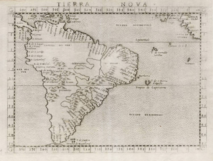
Ruscelli / Gastaldi - Tierra Nova
Certificate of Authentication
This is to certify that the item illustrated and described below is a genuine and
original antique map or print that was published on or near the given date.
Dr Leendert Helmink, Ph.D.
Cartographer
Girolamo Ruscelli
First Published
Venice, 1561
This edition
1562 first state
Size
17.9 x 24.5 cms
Technique
Copper engraving
Stock number
18857
Condition
excellent
Description
Pristine example of Ruscelli's map of South America. One of the first separate maps dedicated to the sub continent it that is obtainable.
First state, with the copperplate running off the top edge.
Ruscelli's famous map of South America is an enlarged engraving of Giacomo Gastaldi's 1548 miniature map of the same, the first map dedicated to the region, entirely based on the Portuguese and Spanish explorations. The Amazon River is referred to as the Marañón River. Interestingly, the toponyms on the northern and eastern coasts are engraved upside down, as they would appear when sailing from Europe to the Strait of Magellan.
Castilla de Oro or del Oro (Golden Castile) was the name given by the Spanish settlers at the beginning of the 16th century to the Central American territories from the Gulf of Urabá, near today's Colombian-Panamanian border, to the Belén River. The name "Castilla de Oro" was made official in May 1513 by King Ferdinand II of Aragon, then regent of the Crown of Castile.
"Published in Gastaldi's miniature version of Ptolemy's 'Geographia', this is one of the most important maps within the atlas. Versions of the 1561 and a later issue of this map by Ruscelli may be found and are interesting additions to a collection as the earliest, reasonably-priced, obtainable maps of the continent."
(Potter on the 1548 Gastaldi prototype of this map).
Girolamo Ruscelli (1504-1566)
Girolamo Ruscelli (1504 Viterbo -1566 Venice), an Italian Alchemist, Physician and cartographer, was editor of a revised and expanded Italian edition of Ptolemy's 'Geographia', published as 'La Geografia di Claudio Tolomeo. The newly engraved maps were based, generally, on those compiled by Giacomo Gastaldi for the Venice miniature atlas edition of 1548.
Ruscelli's atlas was issued several times between 1561 and 1599 by the following publishers
- Venice, Vincenzo Valgrisi, 1561
- Venice, Vincenzo Valgrisi, 1562
- Venice, G. Zileti, 1564
- Venice, G. Zileti, 1574
- Venice, Heirs of Melchior Sessa, 1598-99
The Ruscelli and Gastaldi atlases were the most comprehensive atlases produced between Martin Waldseemüller's 'Geographia' of 1513, and Abraham Ortelius 'Theatrum' of 1570. The significance of the Gastaldi and Ruscelli atlases cannot be overestimated. They defined the known geography of the world for decades. These atlases also reintroduced the use of copper engraving into the service of cartography, which was dominated by woodcut printing after several not very succesful attempts to print from copper in the 15th century. The Gastaldi and Ruscelli atlases proved that maps could be beautifully engraved on copper. As it was a harder material than wood, it was harder to engrave but also gave the ability to render much more detail. The Gastaldi and Ruscelli atlases marked a turning point in the history of cartography, from then on the majority of cartographic works used this medium.
"Ruscelli was editor of a revised and expanded edition of Ptolemy's Geographia which was issued in Venice several times between 1561 and the end of the century.
The newly angraved maps were based, generally, on those compiled by Giacomo Gastaldi for the Venice edition of 1548."
(Moreland & Bannister).