Leen Helmink Antique Maps & Atlases
www.helmink.com
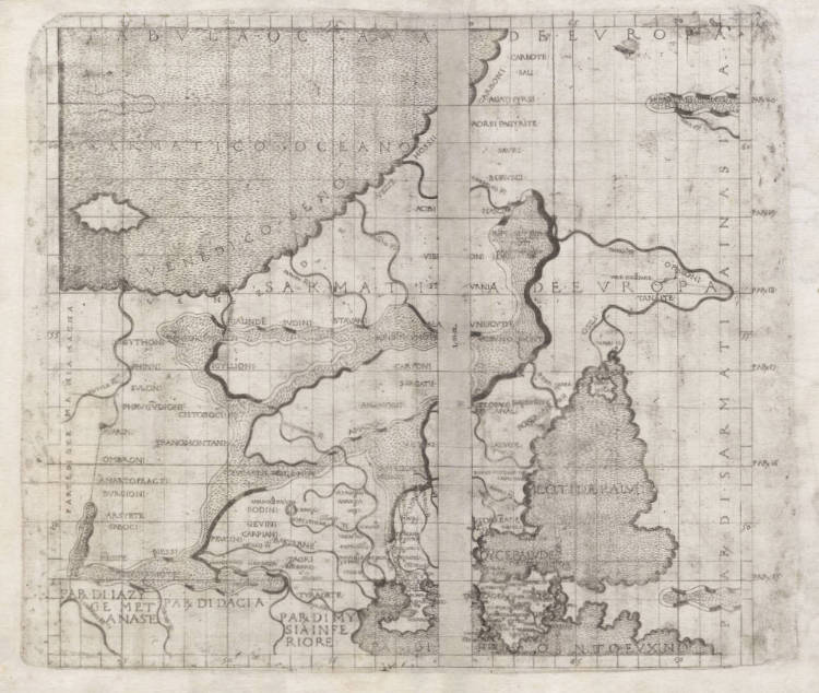
Berlinghieri / Ptolemy - Tabula Octava de Europa
Certificate of Authentication
This is to certify that the item illustrated and described below is a genuine and
original antique map or print that was published on or near the given date.
Dr Leendert Helmink, Ph.D.
Cartographer
Francesco Berlinghieri
First Published
Florence, 1482
This edition
1482
Size
39.5 x 47 cms
Technique
Copper engraving
Stock number
18827
Condition
excellent
Description
Very early and extremely rare Ptolemaic incunabula map centered on Russia, Poland, Belarus, Ukraine, the Baltic States, much of central and eastern Europe, and Northern Europe. The map stretches from the Vistula River in the west to the Tanais (Don) river in the east, and from the Baltic at the top to the Black Sea at the bottom.
Much of the lettering is not engraved, but carried out with letter punches.
It is only the third printed edition of Ptolemy's Geographica with maps, preceded only by the 1477 Bologna and the 1478 Rome editions. The first atlas to be printed in the vernacular, and the first atlas expanded with modern maps. They are also the first maps to use the projection of Marinus of Tyre, instead of Ptolemy's projection.
The map is of exceptional rarity. The last example was offered by Dick Arkway in 2008, and is in fact this very same copy.
Condition
First and only edition of this highly significant map. A good imprint of the copperplate. Two sheets joined, with some minor centerfold restorations as always (because the map was stitched it the atlas, instead of glued to a paper stub). Ample margins all around. Excellent collector's condition.
Francesco Berlinghieri (1440-1501)
Francesco di Nicoli Berlinghieri (1440-1501) was a member of an old Florentine family and he held a number of official posts in that city. He was hardly a geographer and certainly in no sense a cartographer.
The identity of the engraver of the maps remains in dispute but it is believed by some to be Francesco Roselli who was one of the earliest known map sellers and active in Florence up to his death in 1513.
The maps in Berlinghieri's atlas are the only ones in any edition of Ptolemy printed on the original Ptolemaic projection with equidistant meridians and parallels. Unlike other early Ptolemaic atlases, sets of Berlinghieri's maps were sold separately without text. The maps were not reprinted.