Leen Helmink Antique Maps & Atlases
www.helmink.com
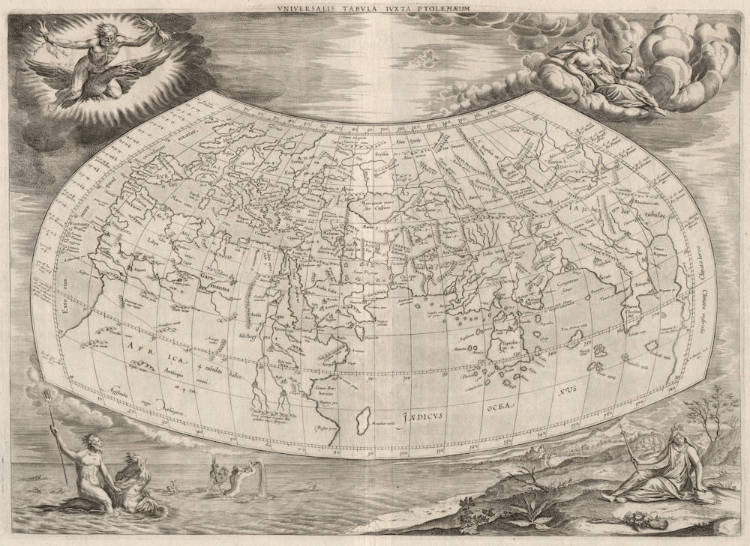
Mercator / Ptolemy - Universalis Tabula Iuxta Ptolemaeum
Certificate of Authentication
This is to certify that the item illustrated and described below is a genuine and
original antique map or print that was published on or near the given date.
Dr Leendert Helmink, Ph.D.
Cartographer
Gerard Mercator
First Published
Duisburg, 1578
This edition
Franeker, 1695
Size
34 x 48 cms
Technique
Copper engraving
Stock number
18820
Condition
excellent
Description
Gerard Mercator's version of Ptolemy's map of the world.
Claudius Ptolemy was librarian of the famous library of Alexandria and he had developed these maps for his "Geographia" around 150 AD and they reflect the best Roman geographical knowledge.
The work was rediscovered in the 15th century and the maps were reissued in the sixteenth and 17th century. The versions by the great cartographer Gerard Mercator are generally considered the most decorative and most skillful rendering of Ptolemy maps.
"The time and effort Mercator put into his revision of Ptolemy's Geographia was part of a grand scheme, occupying most of Mercator's life to describe the whole ancient and modern world geographically and historically. His general Ptolemaic map is one of the finest available. Engraved on copper by Mercator himself, it is framed within a decorative border containing twelve named windheads.
Mercator's plates in his Geographia represent some of his best work and such was their excellence that seven further editions were printed from them. The initial plate, unaltered, was used for editions from Cologne in 1584, Frankfurt and Amsterdam in 1605, and from Leiden and Amsterdam in 1618–19. For the later editions from Franeker and Utrecht in 1695 and 1698, from Leiden, Amsterdam and Utrecht in 1704 and from Amsterdam in 1730 the border of the plate was extensively reworked and replaced by allegorical figures representing earth, air, fire and water. Copies of this reworked plate have also been found in Dutch bibles dating from the 1730s."
(Shirley map 139 state 2).
The work was rediscovered in the 15th century and the maps were reissued in the sixteenth and 17th century. The versions by the great cartographer Gerard Mercator are generally considered the most decorative and most skillful rendering of Ptolemy maps.
(van der Krogt [0900:1.2]
"Coloniæ Agrippinæ 1578. Fol. Tabula Geooraphicæ Cl. Ptolemaei ad mentem autoris restitute et emendata per Gerardum Mercatorem Illustriss: Ducis Clivia etc. Cosmographum.
This edition, the first with Mercator's series of maps, contains only the 27 old maps of Ptolemy in double folio, and a smaller one of the Delta of Nile. All the maps are printed from plates engraved in a masterly style by Gerard Mercator. This edition does not contain the text of Ptolemy, but extensive explanations of the modifications introduced in the accepted Ptolemaic types are printed on the reverse of the maps. An elaborate index of the 7,000 names in Ptolemy's geography concludes the work.
(Nordenskiöld 35).
Gerard Mercator (Kremer) 1512-1594
Arnold Mercator (son) 1537–1587
Rumold Mercator (son) c. 1545– c. 1599
Bartholomeus Mercator (son) fl. 1540-1563
Gerard Mercator (grandson) c. 1563-1656
Joannes Mercator (grandson) c. 1562-1595
Michael Mercator (grandson) c. 1567–1600
"For nearly sixty years, during the most important and exciting period in the story of modern map making, Gerard Mercator was the supreme cartographer, his name, second only to Ptolemy, synonymous with the form of map projection still in use today. Although not the inventor of this type of projection he was the first to apply it to navigational charts in such a form that compass bearings could be plotted on charts in straight lines, thereby providing seamen with a solution to an age-old problem of navigation at sea.
His influence transformed land surveying and his researches and calculations led him to break away from Ptolemy conception of the size and outline of the Continents, Drastically reducing the longitudinal length of Europe and Asia and altering the shape of the Old World as visualized in the early sixteenth century.
Mercator was born in Rupelmonde in Flanders and studied in Louvain under Gemma Frisius, Dutch writer, astronomer and mathematician. He established himself there as a cartographer and instrument and globe maker, and when he was twenty-five drew and engraved his first map (of Palestine) and went on to produce a map of Flanders (1540) supervising the surveying and completing the drafting and engraving himself.
The excellence of his work brought him the patronage of Charles V for whom he constructed a globe, but in spite of his favour with the Emperor he was caught up in the persecution of Lutheran protestants and charged with heresy, fortunately without serious consequences. No doubt the fear of further persecution influenced his move in 15 s 2 to Duisburg, where he continued the production of maps, globes and instruments culminating in large-scale maps Europe (1954), the British Isles (1564) and the famous World Map on 18 sheets drawn to his new projection (1969). All these early maps are exceedingly rare, some being known by only one copy.
In later life he devoted himself to his edition of the maps in Ptolemy's Geographia, reproduced in his own engraving as nearly as possible in their original form, and to the preparation of his 3-volume collection of maps to which, for the first time, the word 'Atlas' was applied. The word was chosen, he wrote, 'to honour the Titan, Atlas, King of Mauritania, a learned philosopher, mathematician and astronomer'. The first two parts of the Atlas were published in 1583 and 1589 and the third, with the first two making a complete edition, in 1595, the year after Mercator's death.
Mercator's sons and grandsons, named above, were all cartographers and made their contributions in various ways to the great atlas. Rumold, in particular, was responsible for the complete edition in 1595. After a second complete edition in 1602, the map plates were bought in 1604 by Jodocus Hondius who, with his sons, Jodocus II and Henricus, published enlarged editions which dominated the map market for the following twenty to thirty years."
(Moreland & Bannister).