Leen Helmink Antique Maps & Atlases
www.helmink.com
Ruscelli / Gastaldi - Tierra Nueva
Certificate of Authentication
This is to certify that the item illustrated and described below is a genuine and
original antique map or print that was published on or near the given date.
Dr Leendert Helmink, Ph.D.
Cartographer
Girolamo Ruscelli
First Published
Venice, 1561
This edition
1574 Italian, state 2
Size
18.0 x 24.5 cms
Technique
Copper engraving
Stock number
18805
Condition
excellent
Description
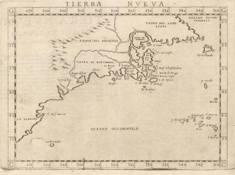
"Ruscelli's edition of Ptolemy's 'Geography' included newly engraved copper plates by Giulio and Livio Sanuto. This map of the east coast is an enlarged version of Giacomo Gastaldi's published in 1548. The nomenclature and cartography are unchanged, with the exception of the depiction of the rivers. Here he borrowed the assumption of Ramusio that the Hudson and St. Lawrence Rivers, as we know them today, were connected upriver. [...]
It is one of two [maps] that were engraved on the same plate, printed and then separated for the book. Evidence can be seen from the fact that plate mark of the maps runs off the top of the page."
(Burden).
"One of the first obtainable maps to concentrate on the North East coastline of North America and one of the first to name Bermuda."
(Arkway).
"Gastaldi has combined data from the Verrazano and Cartier voyages to create this the first printed map devoted to the East Coast of North America. Originally published by Gastaldi in 1548, it is here re-engraved about twice the size by Ruscelli.
When Verrazano scouted the East Coast of North America, he cautiously headed out to sea after Narragansett Bay to avoid treacherous shoals, but in doing so missed Cape Cod and much of the New England coast. Cartier, on the other hand, did not venture further south than Cape Breton. As a result, Gastaldi grafts eastern Canada onto southern New England, with Cape Breton Island sprouting directly from Narragansett Bay. Mercifully, Gastaldi ignores Verrazano's famous Outer Banks "isthmus" report and spares the coast the distortion that arose therefrom; unfortunately, though, he does not incorporate data from Cartier's exploration of the St. Lawrence on his second voyage.
Fresh influence from Verrazano is seen in the Northeast, where a new domain makes its debut on a printed map: along with the familiar regions of Laborador and Bacalaos lies Tierra de Nurumberg.The term originated with the voyage of Verrazano, or at least it first appeared on the portolan made by his brother Girolamo. It appears as "Oranbega" on the Girolamo Verrazano portolan (manuscript, 1529). Although Gastaldi's spelling suggests that he associated it with the German city, it was more commonly spelled "Norumbega" and was probably derived from an Algonquian Indian word which meant something on the order of 'quiet place between two rapids.' The term soon came to denote the region of New England. Further south is New York, calibrated about 5 degrees too far north, and called Angoulesme after Verrazano's designation, Angoleme. The flat shore just up the coast from it, near the name Flora, is Long Island but without Long Island Sound. Near Larcadia are two inlets, probably the Chesapeake and Delaware Bays."
(Suárez).
Girolamo Ruscelli (1504-1566)
Girolamo Ruscelli (1504 Viterbo -1566 Venice), an Italian Alchemist, Physician and cartographer, was editor of a revised and expanded Italian edition of Ptolemy's 'Geographia', published as 'La Geografia di Claudio Tolomeo. The newly engraved maps were based, generally, on those compiled by Giacomo Gastaldi for the Venice miniature atlas edition of 1548.
Ruscelli's atlas was issued several times between 1561 and 1599 by the following publishers
- Venice, Vincenzo Valgrisi, 1561
- Venice, Vincenzo Valgrisi, 1562
- Venice, G. Zileti, 1564
- Venice, G. Zileti, 1574
- Venice, Heirs of Melchior Sessa, 1598-99
The Ruscelli and Gastaldi atlases were the most comprehensive atlases produced between Martin Waldseemüller's 'Geographia' of 1513, and Abraham Ortelius 'Theatrum' of 1570. The significance of the Gastaldi and Ruscelli atlases cannot be overestimated. They defined the known geography of the world for decades. These atlases also reintroduced the use of copper engraving into the service of cartography, which was dominated by woodcut printing after several not very succesful attempts to print from copper in the 15th century. The Gastaldi and Ruscelli atlases proved that maps could be beautifully engraved on copper. As it was a harder material than wood, it was harder to engrave but also gave the ability to render much more detail. The Gastaldi and Ruscelli atlases marked a turning point in the history of cartography, from then on the majority of cartographic works used this medium.
"Ruscelli was editor of a revised and expanded edition of Ptolemy's Geographia which was issued in Venice several times between 1561 and the end of the century.
The newly angraved maps were based, generally, on those compiled by Giacomo Gastaldi for the Venice edition of 1548."
(Moreland & Bannister).