Leen Helmink Antique Maps & Atlases
www.helmink.com
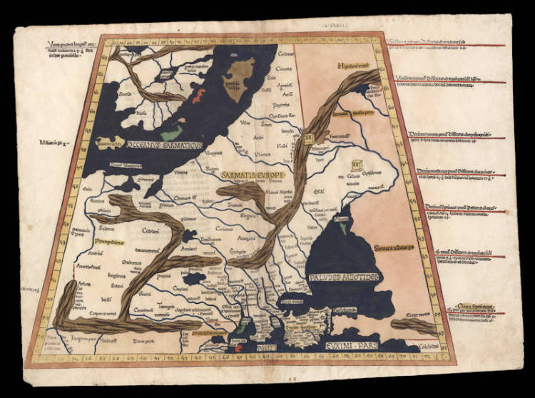
Ulm Ptolemy - Tabula Octava
Certificate of Authentication
This is to certify that the item illustrated and described below is a genuine and
original antique map or print that was published on or near the given date.
Dr Leendert Helmink, Ph.D.
Cartographer
Lienhart Holle / Nicolaus Germanus
First Published
Ulm, 1482
This edition
1486
Size
38.0 x 55.5 cms
Technique
Stock number
18756
Condition
excellent
Description
Nicolaus Germanus' spectacular version of Ptolemy's eight map of Europe, covering today's Russia, Eastern Europe and Scandinavia. Very rare.
From the second 1486 edition of the celebrated Ulm Ptolemy of 1482, which was the first atlas printed outside Italy and the first atlas illustrated with woodcut maps.
This example in beautiful original color from the publisher. Pristine condition. A strong and even impression of the woodblock. Collector's example.
"This striking map depicts Russia and Eastern Europe as envisaged by the second century A.D, cartographer Claudius Ptolemaeus, and is one of the earliest obtainable printed maps of the area. The map extends from the Baltic Sea in the north to the Crimea and the Black Sea. To the west is the Vistula river ("istula fluvius"), with a distended Azov Sea in the east. The majority of the map is marked "Sarmatia Europe" - the Sarmatian kingdom ruled a great swathe of central Asia between the fifth century BC and the fourth century AD. At its highly around the first century B.C. the empire stretched to the banks of the river Vistula.
(Daniel Crouch Rare Books)
Lienhart Holle / Nicolaus Germanus
"As far as cartography is concerned the printing of Ptolemy's Geographia at Ulm in 1482 (and 1486) - the first edition with woodcut maps - was an event of the greatest importance.
The edition of Ptolemy's Geographia printed at Ulm in 1482 was the first published outside Italy and the first with woodcut map; it contained 26 maps based on Ptolemy and six 'modern' maps"
(Moreland & Bannister)
"The first edition printed north of the Alps, and the first woodcut version, is more crudely executed than the previous (Ptolemy) productions. Nevertheless the bold Germanic style and the Gothic lettering have a distinctive decorative appeal, especially when combined with rich colouring. The printer was Leinhart Holle, also known for the publication of the illustrated book Buch der Weisheit.
Shortly after the publication Leinhart Holle went bankrupt. His stock was taken iover by Johann Reger who, four years later in 1486, put out a second printing of about 1000 copies. Within and between both editions variations occur in respect of the text and printed legends although the same basic blocks were used."
(Shirley)
"In 1482 Lienhart Holle in Ulm published a revised edition of Ptolemy's Geographia with the reworking of the Ptolemaic corpus by the cartographer Nicolaus Germanus Donis. The atlas included five additional "modern" maps: Italy, Spain, France, Scandinavia, and the Holy Land. The atlas would be the first book printed by Lienhart Holle, however, it would appear that the venture proved ruinously expensive and his business would go bankrupt shortly after publication. The remaining sheets, the woodblocks and the types passed to Johann Reger in Ulm, who reissued the work in 1486.
As well as the modern maps the atlas bears some other notable first. It was the first time that maps were signed by the artist responsible for the woodcutting; in this case Johannes of Armsheim, who signed the world map, and incorporated a backwards N into the woodcut text on each map. It is also the first to print the accompanying text on the verso of the map to which it refers."
(Skelton)