Leen Helmink Antique Maps & Atlases
www.helmink.com
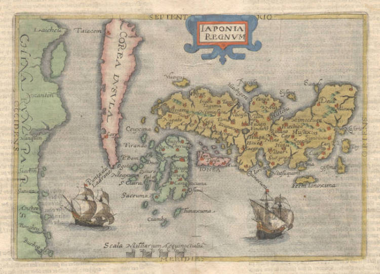
Andreas/Botero/Metellus - Iaponia Regnum
Certificate of Authentication
This is to certify that the item illustrated and described below is a genuine and
original antique map or print that was published on or near the given date.
Dr Leendert Helmink, Ph.D.

Cartographer
Giovanni Botero
First Published
Cologne, 1596
This edition
1598
Size
14.5 x 21 cms
Technique
Copper engraving
Stock number
18675
Condition
mint
Description
First published in Botero's "Theatrum Principum Orbis Universi ... Cologne, 1596".
Extremely rare and early map of Japan and Korea. The map has no latitude and longitude coordinates.
The publication of Giovanni Botero's Theatrum in 1596 marked the first occasion when Ortelius's map was copied by reduction in size to some 60%. The reduction meant that the inclusion of so many place-names, taken from the Ortelius original, cover the landscape. The engraver also copied two of the ships and produced a simplified version of the strapwork surrounding the title. The map also appears in works by Johannes Metellus (Jean Matal).
The map originally published by Botero was exclusively used in his publications from 1596 to 1599. As of 1600, the map was also used, unchanged, in Metellus's Asia Tabvlis Æneis and Speculum Orbis Terrae.
Based on detailed comparison made between examples of the map included in Theatrum Principium... 1596 and that included in the Specvlvm Orbis Terre... 1602, it would appear that there is only one state of this map.
(Hubbard)
Ref: Meurer BOT 1 map Bot 17.
Giovanni Botero (1533-1617)
Giovanni Botero (1533-1617) was born in Bene, Piemonte. He received a Jesuit education and entered the Order, becoming a teacher of rhetoric and philosophy in Italy and France. He was one of the greatest economists of the sixteenth century and considered a precursor of Malthus. He was expelled from the Order after delivering a sermon where he criticized the worldly authority of the Pope. His first geographical work, Le Relationi Universali, was published in 1591 but contained no maps.
(Hubbard)