Leen Helmink Antique Maps & Atlases
www.helmink.com
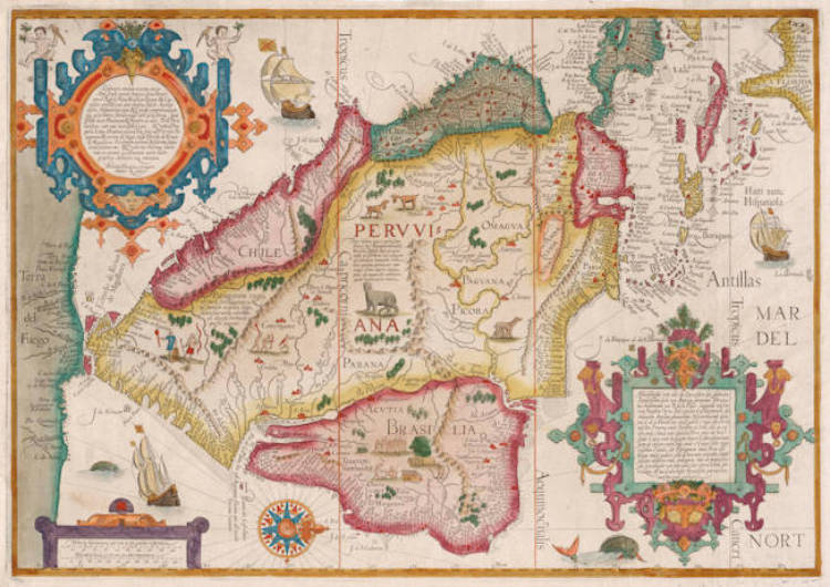
van Linschoten - Deliniatio omnium orarum totius Australis partis Americae, dictae Peruvianae, ... Afbeeldinghe van alle ...
Certificate of Authentication
This is to certify that the item illustrated and described below is a genuine and
original antique map or print that was published on or near the given date.
Dr Leendert Helmink, Ph.D.
Cartographer
Jan Huygen van Linschoten
First Published
Amsterdam, 1596
This edition
1599 Latin
Size
39.0 x 56.0 cms
Technique
Copper engraving
Stock number
17356
Condition
excellent
Description
One of the most important maps of South America. The map is highly spectacular and dramatic and is highly sought-after. West at the top.
The Itinerario provided detailed practical information on how to get to and carry on the trade with America and India. The work was indispensible to sailors on the route to the Indies; it provided a dictionary of exotic commodities, of national trading methods, etc. Linschoten's work, along with Hakluyt's, served as a direct stimulus to the building of the vast English and Dutch overseas empires. Copies were on board of every East Indiaman.
Jan Huygen van Linschoten (1563-1610)
The five detail maps of Van Linschoten's Itinerario, all of which were engraved by Arnold Floris and Hendrik Floris van Langren, cover a large proportion of the non-European world known at the time. According to the map titles, these detail maps were composed with the aid of the best Portuguese and Spanish charts and rutters. These maps clearly reveal the influence of the set of maps that Cornelis Claesz had already published previously (1592-94), for which Petrus Plancius was responsible. Plancius's maps were copied for inclusion into Van Linschoten's work. These copies differ only in minor details from the originals.
(Schilder)
Van Linschoten, born in Haarlem, is heard of in the service of the Portuguese Archbishop of Goa where he spent five years between 1583 and 1588.
On his return to Holland he produced a History of his travels, important for the inclusion of maps from Portuguese sources, at that time rarely available to Dutch – or any other – cartographers. The maps (including a world map by Petrus Plancius) engraved by van Langren, are highly decorative with large cartouches, the arms of Portugal, compass roses, rhumb lines and sea monsters. Some are illustrated with views of prominent places or islands.
(Moreland and Bannister)