Leen Helmink Antique Maps
Antique map of Saldanha Bay by Widow Johannes van Keulen and Sons

Stock number: 19711
Zoom ImageCartographer(s)
Johannes van Keulen II (biography)
Title
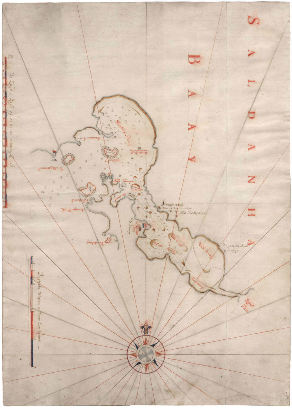
Saldanha Baay
First Published
Amsterdam, 1775
This Edition
1775
Size
51 x 72.5 cms
Technique
Condition
pristine
Price
$ 17,500.00
(Convert price to other currencies)
Description
Unrecorded and highly detailed VOC master chart (legger), being a VOC manuscript sea chart of Saldanha Bay in South Africa, part of the Cape Colony, prepared by the van Keulen publishing house.
The watermark allows for precise dating of the paper to 1775, meaning that the chart was prepared by "the Widow Johannes van Keulen and Sons", who was responsible for the provision of charts and nautical equipment to the VOC after her husband Johannes van Keulen II had passed away in 1755.
The chart was not part of the canon of sea charts that were on board of VOC East Indiamen, they used a set of four smaller and less detailed charts for the waters around Cape of Good Hope.
Dedicated highly detailed charts like this were produced for the archives of the VOC, to ensure they had the best possible charts of any of all waters and ports between Amsterdam and Japan. One of the duties of the VOC governors of VOC posts and of the pilots of VOC East Indiamen was to send accurately updated charts of all waters.
Besides providing charts to the VOC, the Van Keulen publishing house also sold to outside markets.
A "master chart" or legger like this would be used to produce individual copies to clients, which by then could be the VOC but also to other non-VOC seafaring companies. It stands to reason that many of them would have been from outside the Dutch Republic.
VOC Saldanha Bay post
From the moment the Dutch VOC established the Cape Colony in 1652, Governor General Jan van Riebeeck also took control of Saldanha Bay.
Saldanha Bay, named after Portuguese navigator António de Saldanha, was known for its natural harbor but was limited by a lack of fresh water, making it unsuitable for a permanent settlement like Cape Town.
It was however of utmost strategic importancve, located less than 100 miles north of the Cape, and the closest deepwater harbour near the Cape.
It was used as an outpost within the Cape Colony, used for trade, stock-raising, and as a stopover for ships, supporting Cape Town’s primary role.
The bay’s sheltered harbor made it suitable for anchoring, and its proximity to Khoikhoi grazing routes facilitated trade.
It served as harbour to provision homebound ships that had missed the Cape, and offered a safe shelter from storms and enemy fleets.
Saldanha Bay had a company post, a timber wharf to repairs ships, and the chart shows an area for mining salt.
From 1652 to 1799, Saldanha Bay was also of great strategic importance to the Dutch East Incia Company. The British and French East India Companies were always eying to capture it, to have their own stopover to and from the Indies, as an alternative to the VOC's Cape of Good Hope.
Rarity
Unrecorded, lacking in all collections.
Significance
VOC master charts are of utmost rarity. Detailed large scale sea charts of Saldanha Bay are unrecorded.
Condition description
Watermark van Gelder 1775. Thick and clean paper. No restorations or imperfections. Pristine condition.
Johannes van Keulen (1654-1711)
Gerard van Keulen (son) (1678-c.1727)
Johannes van Keulen II (grandson) (active 1726-1755)
The Dutch produced a remarkable number of enterprising and prolific map and chart makers but not even the Blaeu and Jansson establishments could rival the vigour of the van Keulen family whose business was founded in 1680 and continued under their name until 1823 and in other names until 1885 when it was from wound up and the stock dispersed at auction.
Throughout the history of the family, the widows several of the van Keulens played a major part, after their husbands' deaths, in maintaining the continuity of the business. The firm was founded by Johannes van Keulen who was registered as a bookseller in Amsterdam in 1678. In 1680 he published the first part of his 'Zee Atlas' which, over the years, was expanded to 5 volumes and continued in one form or another until 1734. More ambitious and with a far longer and more complicated life was his book of sea charts, the 'Zee-Fakkel', first published in 1681–82, which was still being printed round the year 1800. A major influence in the development of the firm was the acquisition in 1693 of the stock of a rival map publisher, Hendrik Doncker.
Although the firm was founded by Johannes van Keulen, he was primarily a publisher; it was his son, Gerard, a talented engraver, mathematician, Hydrographer to the East India Company, who became mainspring of the business which not only published charts but also books on every aspect of geograpy, navigation and nautical matters,
(Moreland and Bannister)
It was grandson Johannes van Keulen (II) who in 1753 produced Volume VI of the Zee-Fakkel for the VOC East Indiamen, containing printed charts for the navigation covering the waters from the Cape of Good Hope to Nagasaki . The atlas was not commercially sold and only for use on board of VOC ships, therefore it is also refered to as the 'secret atlas' odf the VOC. The engraving quality and craftmanship surpasses that of all earlier printed sea charts.
Sea charts from the secret atlas are among the rarest and most desirable sea charts for collectors.

