Leen Helmink Antique Maps
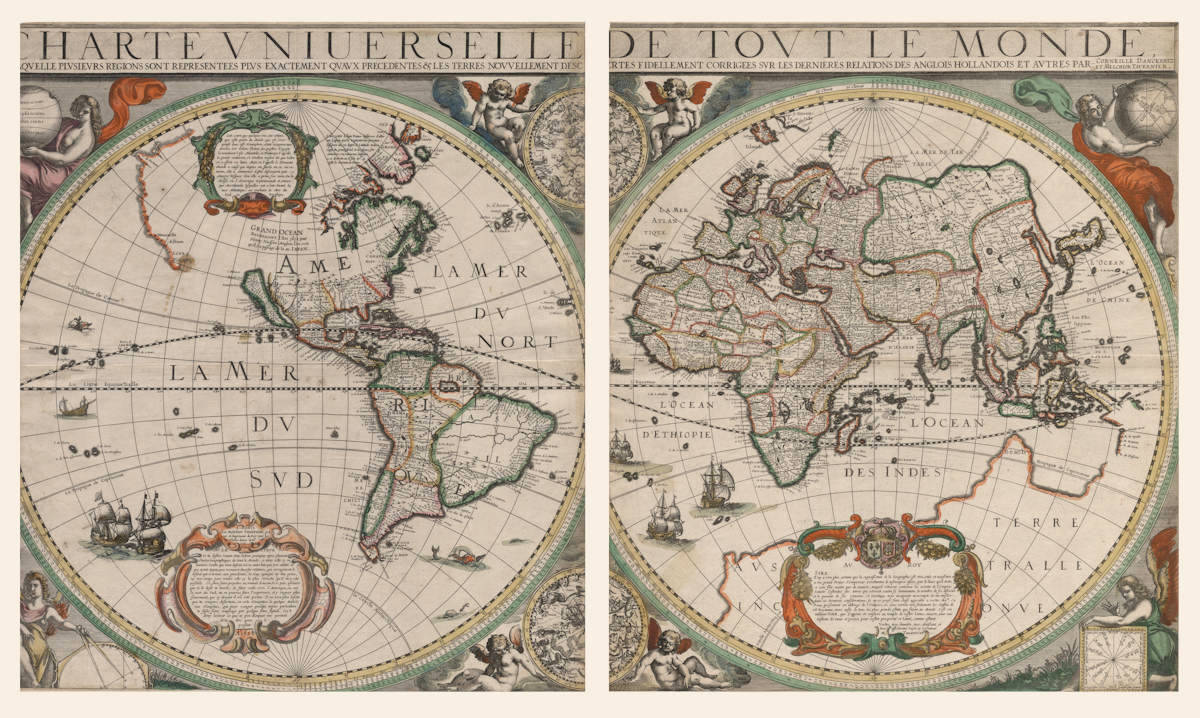
Antique map of the World by Danckerts-Tavernier
The item below has been sold, but if you enter your email address we will notify you in case we have another example that is not yet listed or as soon as we receive another example.
Stock number: 18988
Zoom ImageCartographer(s)
Danckerts-Tavernier
Title
Charte Universelle De Tout Le Monde
First Published
Paris, 1628
This Edition
1628 first state
Size
51.5 x 91.0 cms
Technique
Condition
excellent
Price
This Item is Sold
Description
Summary
Very large map of the world, printed on two sheets. It is the oldest printed map to show Carstensz's 1623 discoveries in Australia. Only six copies survive.
In 1623, following Jansz's 1606 discoveries, a new expedition was organized under the command of Jan Carstensz in the ships the Pera and the Arnhem to further explore the lands Jansz had happened upon some seventeen years earlier. On 21 January, 1623, Carstensz left Amhoina, finally reaching the area of Torres Strait by the end of March. Carstensz and his crew sailed south until they reached latitude 17° 8' south on 24 April, 1623. At this point the two boats turned around and parted company. Van Colster in the Arnhem sailed in a westerly direction, eventually charting some of the coastline to the west of the Cape. Carstensz on the other hand continued sailing north naming several places along Cape York Peninsula.
Currently no Australian institution holds a copy of this seminal map. The known institutional copies are held in the Library of Congress, the Bibliothèque Nationale and the British Library. Two copies are in private collections.
(Simon Dewez)
Condition
Thick paper. Printed on two sheets in fine original colour. Each hemisphere slightly trimmed at left hand side, slightly affecting the image. Otherwise excellent for an unobtainable map of highest significance.
Overall excellent appearance. Separately published - Paris 1628.
Provenance
Ex private collection, 2021.
Ex Gowrie Galleries, The Printed World III, item 59, 2000. Prominently on display in the corresponding exhibition In Search of Southern Soil - An exhibition of Rare Maps, Books and Globes, documenting the discovery of Terra Australis and Australia - 1482 to 1822. Queen Victoria Building, Sydney, Australia, March-April 2000.
Descriptions from the literature
Cornelis Danckerts - Melchior Tavernier
Paris, 1628.
515 x 910 mm.
"Charte Universelle De Tout Le Monde ... Par Corneille Danckertz et Melchior Tavernier"
"A Paris chez Melchior Tavernier ... A° 1628".
[Separate publication]
THIS UP-TO-DATE and well-constructed map printed on two sheets is the joint effort of Cornelis Danckerts from Amsterdam and the Parisian Melchior Tavernier who describes himself as graveur et imprimeur du Roy. The map is dedicated by Tavernier to the King of France and the title says that it has been corrected by the latest discoveries of the English, Dutch, etc. There are majestic cherubic figures in the spandrels and on either side of the central celestial hemispheres.
It is the first world map to mark, with names, Carstensz.' discoveries of 1623 on the western coast of [Cape York Peninsula in] Australia. The outline of the old southern continent is still shown on the eastern hemisphere but there is no such outline on the western part. In the Americas, the coastline beyond California is left uncertain; in the central part of north America a large inland sea is marked Grand Ocean with a note in French saying that this was discovered by Henry Hudson in 1612 and suggesting that it may provide a through route to Japan.
About four or five copies of this map survive. One is in the British Library and there is a coloured copy in the Library of Congress. The Bibliothèque Nationale and the University Library in Amsterdam also possess copies [The latter is now known to be a facsimile].
BL Maps 184.i.1.(2). Schilder, p. 96 and plate XVI.
(Rodney Shirley map 323)
Related Categories
Related Items
