Leen Helmink Antique Maps & Atlases
www.helmink.com
Johannes van Keulen
Title page America
Certificate of Authentication and Description
This is to certify that the item illustrated and described below is a genuine antique
map, print or book that was first produced and published in 1684, today 341 years ago.
July 4, 2025
Cartographer(s)
Johannes van Keulen
First Published
Amsterdam, 1684
This edition
1728
Size
47 x 27 cms
Technique
Copper engraving
Stock number
19739
Condition
very good
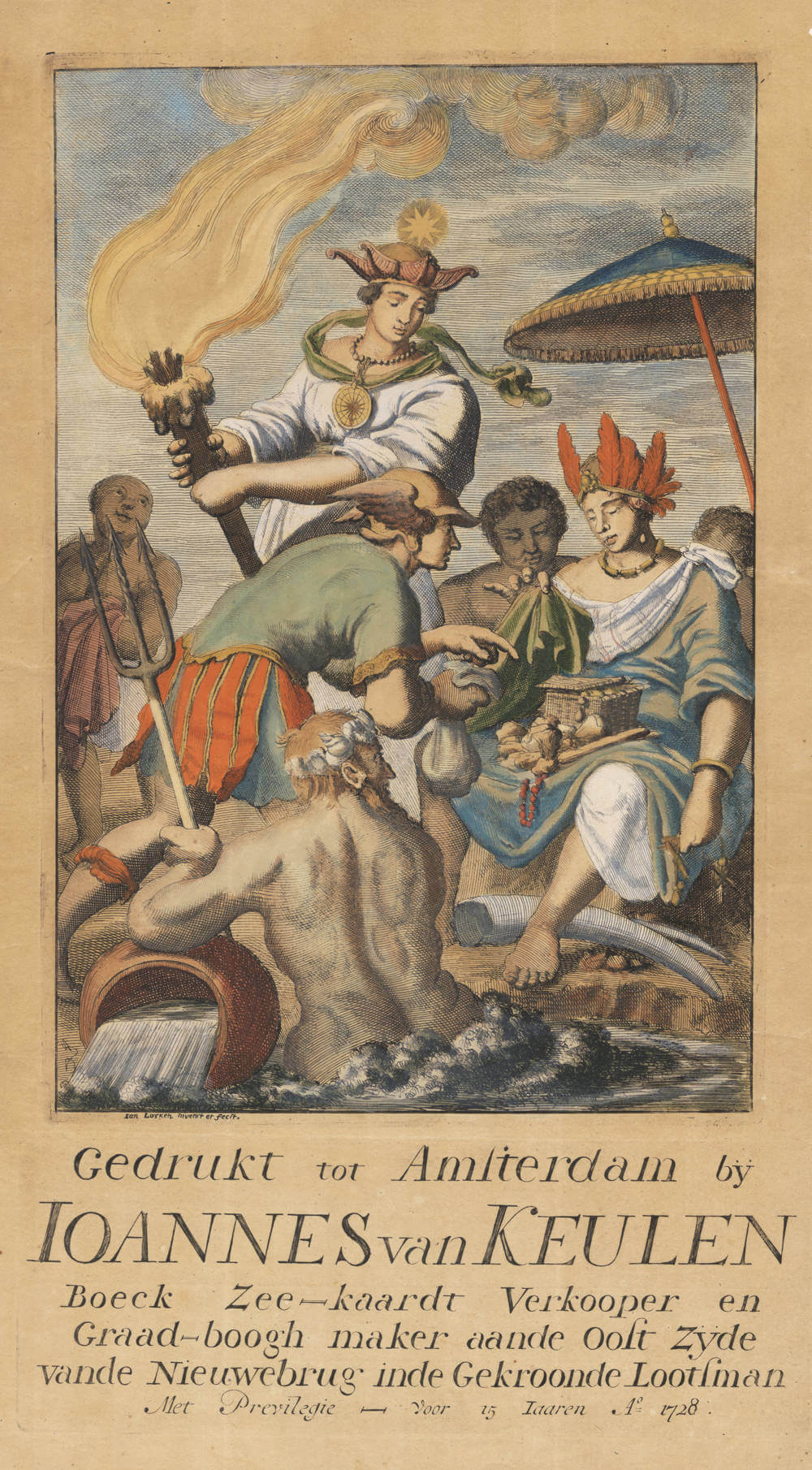
Description
Unrecorded title page from the van Keulen publishing house.
It shows the allegory of America with allegories of navigation, and gods from classical antiquity offering her trading goods.
The title page is obviously intended for the Zee Fakkel (Sea Torch) Part IV, covering the navigation of North America and the Caribbean.
It is dated 1728 and dedicated to Johannes van Keulen (II), who had taken over the business in 1727 after his father Gerard van Keulen passed away.
However, the allegory is signed by Jan Luyken as the designer and etcher, like most of Van Keulen's title pages, which means that the title was almost certainly produced in 1684 for the first issue of the Sea Torch Part IV, for grandfather Johannes van Keulen I.
Rarity
Unrecorded.
Condition
Paper browned, but complete and very good.
Johannes van Keulen (1654-1711)
Gerard van Keulen (son) (1678-c.1727)
Johannes van Keulen II (grandson) (active 1726-1755)
The Dutch produced a remarkable number of enterprising and prolific map and chart makers but not even the Blaeu and Jansson establishments could rival the vigour of the van Keulen family whose business was founded in 1680 and continued under their name until 1823 and in other names until 1885 when it was from wound up and the stock dispersed at auction.
Throughout the history of the family, the widows several of the van Keulens played a major part, after their husbands' deaths, in maintaining the continuity of the business. The firm was founded by Johannes van Keulen who was registered as a bookseller in Amsterdam in 1678. In 1680 he published the first part of his 'Zee Atlas' which, over the years, was expanded to 5 volumes and continued in one form or another until 1734. More ambitious and with a far longer and more complicated life was his book of sea charts, the 'Zee-Fakkel', first published in 1681–82, which was still being printed round the year 1800. A major influence in the development of the firm was the acquisition in 1693 of the stock of a rival map publisher, Hendrik Doncker.
Although the firm was founded by Johannes van Keulen, he was primarily a publisher; it was his son, Gerard, a talented engraver, mathematician, Hydrographer to the East India Company, who became mainspring of the business which not only published charts but also books on every aspect of geograpy, navigation and nautical matters,
(Moreland and Bannister)
It was grandson Johannes van Keulen (II) who in 1753 produced Volume VI of the Zee-Fakkel for the VOC East Indiamen, containing printed charts for the navigation covering the waters from the Cape of Good Hope to Nagasaki . The atlas was not commercially sold and only for use on board of VOC ships, therefore it is also refered to as the 'secret atlas' odf the VOC. The engraving quality and craftmanship surpasses that of all earlier printed sea charts.
Sea charts from the secret atlas are among the rarest and most desirable sea charts for collectors.